Many travellers imagine that the Philippines consists of nothing but beaches and on the best days it can seem like that. But the reality is that the Philippines is a big country – vast even – with huge inland areas dotted with many major cities and towering mountains. Dozens of beaches are almost always nearby but even the most canny of travellers will need to do some serious scratching to find the best of them. This Guide – Manila’s Beaches – The Capital’s Top 60 Seaside Escapes – makes it easy and quick to do just that.This Guide – Manila’s Beaches – The Capital’s Top 60 Seaside Escapes is the first ever comprehensive list of all the major beaches on the big Island of Luzon, providing details on 260 wonderful beaches, including 60 Top Beaches that are ranked among the best beaches in the world.
Together with details on these 260 beaches, the book provides pertinent and entertaining introductions to each of the island’s 17 seaside Provinces and reviews of some of the best resorts at all the beaches around the island.Many people have heard of the major beaches on Luzon – from Laiya Beach near Batangas in the south to Saud Beach next to Pagudpud in the far north – but to date there has never been a guide to the phenomenal variety and attractiveness of the many, many more, lessor known locations, many of them virtually unvisited, and unspoilt.
This Guide – Manila’s Beaches – The Capital’s Top 60 Seaside Escapes provides quick and easy access to information on almost every one of Luzon’s main beaches, from the fabulous Five Finger Coves on Bataan, just west of Manila, to the millionaire’s hideaways on Balesin Island, to the east of Manila, and the extraordinary Babuyan Islands in the extreme north – together with simple guidelines on how to visit them all.
Many Filipinos and everyone travelling to the Philippines can benefit from this guide to the full range of seaside opportunities on the coast, all of which can easily be combined with visits to Luzon’s celebrated major inland attractions from the dynamic city of Manila to the Banaue rice terraces in the north and the major volcanoes, Mayon and Taal, in the south.
2. Searching for the Perfect “Top” Beach
Once upon a time ….
Throughout history beaches were scorned as no go areas synonymous with danger, too exposed and vulnerable to all manner of hazard, from storms and tsunamis to pirates and sea monsters. They were no place any one of any sense wanted to hang around any longer than duty required. People built their shelter inland and in the mountains, daring to hit the beach and dip their toes in the sea only when required.
The prejudice against beaches only began to turn in the18th century when a few doctors in Britain had the crazy idea that certain recurrent maladies were best treated by their patients bathing in the country’s cold sea waves.
And the seaside finally became the go-to place in the early 19th century when pollution from the industrial age factories reached a critical point in Britain’s burgeoning cities and a new fangled invention – railways gave depressed inhabitants the change to get the hell out, at least to their local beaches.
Fast forward 150 years to another transpiration revolution, the launch of cheap air travel, when suddenly ever more people could afford venture further afield … until today when the search for the Perfect “Top” Beach has reached to every corner of the globe.
And the Perfect “Top” Beach is …
Opinions about what makes any Top Beach varies widely, as they do about certain seafoods, like oysters: what is ambrosia for one person is cyanide for another.
There is a universal preference for a beach’s sand to be soft and fine, tending towards pale brown, even white. And invariably it helps to have crystal clear turquoise water on one side of the sand with some foliage, preferably palm trees for shade, on the other.
Beyond these essentials Top Beaches may come in all shapes and sizes. For some the ideal is an easily accessible wide crescent offering stunning views of sunsets on the horizon, for others it’s a remote small cove with calm water sheltered locked in my cliffs.
For some it is a hidden, virtually pristine beach that promises Robinson Crusoe isolation, where it is possible to feel lost, like the only person on the planet.But for others a Top Beach is the precisely the opposite: it has to be easy to get to and highly developed, drawing in bustling crowds and offering them unlimited activities, from room service by the water to kite surfing.
A tropical paradise …
Whatever the definition of your Top Beach, The Philippines is well placed to answer the requirements as it is a 1,800 km / 1,200 m long archipelago of 7,107 tropical islands ranging from from two large islands, Luzon and Mindanao, that book end the archipelago to the north and south, down to hundreds of tiny sparsely populated outposts and myriad atolls that change shape with the tides.
Many of these islands are a reasonable size with towns and cities surrounded by vast expanses of mountain ranges and tropical rain forests offering a wide variety of flora and fauna but far more of them are smaller virgin territories best suited to doing nothing but chilling out.
However, all of them, large and small, offer dreamlike soft sand beaches with crystalline waters protected by world class coral reefs on one hand and shady swaying palm trees on the other.
Luzon has it all …
When it comes to the search for a Perfect Top beach amid the variety in the Philippines, Luzon has an advantage over the country’s other 7,106 islands – it is the largest of them all with more attractions and more beaches.
Unusually shaped / Not shaped like a conventional island, more oblong than circular, it resembles a narrow-waisted chef with a large head sporting a huge chef’s hat.
it varies from a bulky mountainous top third, through a chunky highly urbanised middle then straggling off at the bottom as if its maker had lost interest. to a long, spindly mass at the southern end combining outstanding coves and islands
What a complex island Luzon is!
Highly populated in places but empty and wild in others.
On the one hand, it is known globally for its magnificent inland attractions: from Manila, the country’s capital, to a wide variety of natural splendours like the mountainous rice terraces in the north; spectacular volcanoes, like Mt Mayon and and Taal; and outstanding Spanish architecture from the 17th century.
But it still remains a tropical island with more than 5,000 km / 3,000 miles of coastline, much of it indented with many fine bays and gulfs and coves and not to mention 100s of off-shores islands – all with potential Top Beaches
There used to be great beaches stretching along Manila Bay, especially south from the mouth of the Pasig River. But no growing city gets to be a global player without sacrificing a few amenities. Those beaches have long been lost to land reclamation and pollution. The payback for these losses to progress is Manila now offers transport that can now reach many more new beaches that are even more exotic, spectacular and less crowded.
Finding your way around Luzon ….
Manila, the country’s capital, makes the logical starting point to begin the hunt for Luzon’s Top Beaches because it is not only the first port of call for most visitors to the country but the starting point for the comprehensive network of roads and buses which reach into every corner of the island and to all its beaches.
From Manila, the easiest way to understand Luzon’s vast number of beaches on offer is in terms of the island’s 17 coastal Provinces. These Provinces come in a bewildering variety of shapes and sizes – from bite sized to gargantuan – and the borders between them are entirely invisible.
However, encompassing the coast, they are handy for grouping Luzon’s beaches together, starting with the Province of Bataan, on the far side of Manila Bay, just 30 km / 20 m west of Manila as the crow flies.
- LOOKING FOR TABLE OF CONTENTS
The Western And Northwestern Beaches
3. Luzon’s Beaches:
Route One – Bataan – 170 km / 110 m = 3 hrs from Manila
Route One – Bataan – 170 km / 110 m = 3 hrs from Manila
Route Two – Zambales – 160 km / 105 m = 3.5 hrs from Manila
Route Two – Zambales – 160 km / 105 m = 3.5 hrs from Manila
Route Three – Pangasinan – 220 km / 150 m = 3.5 hrs from Manila
Route Four – La Union – 270 km / 175 m = 5 hrs from Manila
The Far North Beaches
Route Five – Ilocos Sur – 400 km / 250 m = 8 hrs from Manila
Route Six – Ilocos Norte – 480 km / 300 m = 9 hrs from Manila
Route Seven – Cagayan – 640 kms / 400 m = 13 hrs from Manila
Route Eight – Isabela – 450 km / 280 m = 10 hrs from Manila
The East and Southeastern Beaches
Route Nine – Aurora – 230 km / 150 m = 6 hrs from Manila
Route Ten – Quezon – Mainland – 160 km / 100 m = 3.5 hr from Manila
– Islands – 100 km / 60 m = 3.5 hrs from Manila
Route Eleven – Camarines Norte – 350 km / 220 m = 10 hrs from Manila
Route Twelve – Camarines Sur – 400 km / 250 m = 9 hrs from Manila
Route Thirteen – Catanduanes – 500 km / 300 m = 11 hrs from Manila
Route Fourteen – Albay – 530 kms / 340 m = 12 hrs from Manila
Route Fifteen – Sorsogon – 580 km / 360 m = 11 hrs from Manila
The Southwestern Beaches
Route Sixteen – Batangas – 60 km / 40 m = 1.5 hrs from Manila
Route Seventeen – Cavite – 25 km / 15 m = 30 mins from Manila **************************************************************************************************************************************************
MANILA’S SEASIDE ESCAPES – ROUTE 1: THE PROVINCE OF BATAAN
MANILA’S SEASIDE ESCAPES – ROUTE 1: THE PROVINCE OF BATAAN
From Manila: Bus 110 km / 65 m (3 hrs)
to Dinalupihan, northeastern Bataan
Alternatively: Jet ferry (40 mins) from Manila
to Mariveles, southwestern Bataan.
Looks like …. …. the foot of a sock, the toe hanging down
“WHAT’S BATAAN GOT?”
Bataan is a very small Province (71st out of 81 provinces) – roughly 50 km /30 m long and only 25 kms / 15 miles wide – with a comparatively large population of 800,000 (39th out of 81) meaning that it is quite densely populated (8th out of 81).
The Province occupies the entire Bataan Peninsula separating the South China Sea from Manila Bay.
Two dormant volcano occupy 80% of the province. To the north, in the sprawling Bataan National Park, stands Mount Natib (1,250 m / 4,000 ft). The southern part of the Peninsula is dominated by Mount Mariveles (1,400 m / 4,500 ft), the highest peak in the Province. Bataan’s western coast is distinctly jagged with many dramatic ridges, cliffs and headlands but there is a distinct valley running east to west between the two volcanoes and a narrow plain on their eastern side, around the capital city of Balanga (pop. 100,000).
During the second world war, Bataan’s rugged landscape was the scene of one of the last stands of American and Filipino soldiers against the Japanese forces. The Japanese came out on top after a brutal 3 months campaign in early 1942 that left some 10,000 American and Filipino soldiers dead, and nearly 80,000 Allied troops surrendered. These troops were then forced to march 80 km / 50 m inland from western Bataan in sweltering heat, with little food or water. During this ordeal, many of the soldiers dropped dead while others were beaten, stabbed and shot at random, resulting in the deaths of more than 10,000 Filipinos.
Not surprisingly, given this troubled history, many of Bataan’s most popular attractions have a WW2 reference, including a World War II Museum in Balanga; the Shrine of Valor, a 300 ft high cross erected near the edge of Mount Samat’s 550-metre (1,800 ft) wide crater, near the town of Pilar, just south of Balanga; the Flaming Sword Monument, which depicts the bravery of the Filipino and American soldiers during the Second World War, which is also at Pilar; and the Zero Kilometer Marker in Mariveles, in the southwestern corner of the Peninsula, where the Bataan Death March began.
WW2 aside, the Province’s attractions are focussed on outdoor activities, like trekking past rivers and springs to various peaks and waterfalls, like the 200 ft Pasukulan Falls, in the Bataan National Park.
There are at least 10 notable waterfalls in the Province, from Dunsulan, the most accessible, at the foot of Mt Samat, near Pilar on the east coast, to the picturesque, 100 ft high Ambon-Ambon Falls, near Bagac on the west side; San Miguel Peak is a 100 m / 400 ft high rock mountain overlooking Sisiman Bay, east of Mariveles, that is suitable for both trekkers and climbers; and Sibul Spring offers several large swimming pools fed by a natural, cool spring in a forest at the foot of Mr Natibfed, northwest of Balanga.
Nature lovers also like the Pawikan Conservation Center on Nagbalayong Beach south of the west coast town of Morong, where marine turtles are hatched and then released into the sea during a week long Festival; the Tortugas Bay Wetland and Nature Park near Balanga, on the east coast and both the Sinagtala Farm Resort & Adventure Park and Vista Tala Resort & Recreational Park, which are in the mountainous north of the province, just east of Bataan National Park. More active visitors can try the Duhat Bike Trail, a 10 km / 6 m loop that offers scenic views close to the Mt Samat Cross, near Pilar.
Bataan has numerous historic churches, the oldest being the Baroque style Santo Domingo de Guzman, founded by Dominican Friars in 1588.
But the province’s most remarkable architectural attraction is Las Casas Filipinas de Acuzar in Bagac, on Bataan’s west coast, a purpose-built town made up using remarkable ancestral homes and buildings dating from the 18th to the early 20th century.
“WHERE ARE THE BEACHES?”
OVERVIEW
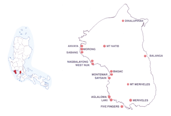
Bataan has water on three sides but its 22 Top Beaches are all on one side only, the rugged 70 km / 50 m long west coast, facing the South China Sea.
DETAILS
Bataan’s Top Beaches run the entire length of the 70 km / 50 m western coastline (2 hrs), dividing into three equal areas around the coast’s three main towns: mountainous Morong, at the top, below Mt Natib in the north; the relative flat lands around Bagac (halfway down); and the remarkably rugged coast of Mariveles in the south.
The Morong coastline stretches some 25 km / 15 m kms southwards, starting with Bataan’s first Top Beach, Anvaya Cove, a beautiful 3.5 km / 2 m long beach lined with luxuriant hills leading to Mt Natib. Anvaya Cove was “discovered” more than a decade ago by one of the country’s leading property companies, Ayala Land Development Corporation, and has ince been developed it into a world class resort with virtually unlimited facilities.
Morong’s less developed beaches begin just a little further south, closer to the main road around Morong town, and run along some 15 kms / 10 m of its coast.
Further south the coastal road passes by Sabang Beach, which has numerous resorts, leading to the 7 km long Nagbalayong Beach, site of the Pawikan Conservation Center for marine turtles.
Shortly after the Conservation Centre, the road passes some distance behind the beautiful West Nuk Beach, which is set in a lovely, deep cove, then turns further inland to twist through the lush mountain forest of Bataan National Park above the peaceful Playa La Caleta, which is set in another deep cove, looking out on a sandy 1-hectare islet called Miguelito Island. Playa La Caleta is best reached by boat from Bagac, the second of Bataan’s west coast districts, a few minutes to the south.
The town of Bagac is situated more or less halfway down Bataan’s western coastline, on the wide, sandy shores of Bagac Bay, followed by two smaller bays, making it a good base for a series of Top Beaches.They begin with several good swimming beaches to the north of the town and a small secluded cove with a beach, Looc Beach (aka La Salle Beach), north of Bagac Bay. Swimming is possible from Bagac town itself.
But Bagac’s Top Beaches are all south of the town. The first is Montemar Beach, conveniently situated only minutes south, on a shallow cove at the south end of Bagac Bay. It boasts a 12-hectare cove with a 500 m / 2,000 ft long powdery white sand beach. Just south of Montemar Beach is another cove, still looking out on Bagac Bay, with a good range of resorts.
But the bulk of Bagac’s Top Beach opportunities are on two larger, deeper coves a few minutes further south of Bagac Bay. The first cove is dominated by Saysain Beach, which has several Top Resorts.
From behind Saysain Beach, the coast road heads inland, meaning that the second cove is even more secluded. Here at Paysawan Beach is a retreat called El Paradiso Private Beach, on the south edge of the cove, reached by a single small road from the main highway.
Soon after Paysawan the coastline grows decidedly more rugged, forcing the coastal road further inland into the shadows of Mt Mariveles, above a series of isolated coves with fine white sand beaches, including Kaibubo Bay and Quinawan Bay, both of which are best accessed by boat from Mariveles the third of Bataan’s west coast districts, a few minutes further south.
Dominated by Mt Mariveles, the highest point in the province at 1,400 m / 4,500 ft, the western coastline of Mariveles is relentlessly rugged and dotted with a dozen or more coves, some large, some small, each with a pristine beach and all best reached by boats from Porto, a short ride from Mariveles town at the extreme southern end of the coast.
Heading north from Porto less than an hour takes visitors to Aglaloma Beach, a beautiful wide, brown sand beach in a sheltered cove, just below Bagac’s Kaibubo Bay and Quinawan Bay. But the Top Beach to the north of Porto, even more eye catching than Aglaloma, is undoubtedly Laki Beach.
… a hidden gem .…in a secluded privately owned cove surrounded by mountains and forest … its white sand and the bluish color of the sea was irresistible … beautiful and the water was clean … I love the sand and the palm trees in the area …. great for camping ….
South of Laki is the amazing Camaya Cove, a 3 km / 2 m long beachwhich has been developed into a residential complex and, something of an exception for this part of the coast, is accessible by car.
Just south of sophisticated Camaya, but still north of Porto, life is simpler again at Lusong Beach and then Talain Beach, both favourite spots for camping.
South from Porto, boats pass several more small coves and beaches including popular Panoypoy Cove Beach and Kinalaklakhan Beach, but the main attraction here is Five Fingers Cove, which includes a series of four small coves created by rocky extensions that jut out like … well, like five fingers.
The Five Fingers or Points are: Cochino’s, Talaga, Hornos / Puntang Mahaba (the longest “finger” of the five), Naiklec and Longos Kawayan.
All five fingers or Points are regularly visited for the viewpoints they offer and for adventurous swimmers: Talaga Point offers a scary 20ft high cliff jump into the Natsu Lagoon and Longos Kawayan offers an even more frightening 40-foot cliff jump into the Tinanlakan Lagoon.
But even dedicated cliff jumpers mainly visit the Five Fingers for the four coves and, particularly, the four outstanding beaches between the fingers:
Talaga Cove (between Cochino and Talaga points)
Apatot Cove (bet Talga and Hornos) named for its many apatot trees
Nagbayog Cove, (bet Hornos / Puntang Mahaba and Naiklec)
Mawakis Cove (between Naiklec and Longos Kawayan)
BATAAN’S TOP RESORTS
– MORONG
Anvaya Cove Beach & Nature Club, Anvaya Cove
…. probably the nicest resort that I ever been to in the Philippines ..… everything is first class from food to accommodation and services … the beach and pools are beautiful with a lifeguard always on duty …. the freestanding tub in our room was most definitely the highlight of our stay …
Anvaya Cove Seabreeze Veranda Condos,
… beautiful resort, grounds, beach and facilities … very peaceful and quiet … the seaside is well-maintained … the rooms were great and the staff were friendly ….
Morong Star Beach Resort,
…. one of the best resorts in Morong … better facilities than any neighbouring resort and still improving … life guards really care …. facilities and activities are really good ….
Island Waters Resort,
…. a great find! … decent sized, well equipped rooms … great central area with grass and a nice pool … staff are excellent and used to dealing with expats and locals alike …. best of all karaoke is BANNED so the evenings are quiet and relaxing …
La Playa At the Strand,
… lovely and quaint place … very private and safe … there is an obvious effort to maintain the beach …
West Nuk Beach Resort
… loved this place … it was amazing …. on the beach, there were less people than I expected and no huge waves …. it’s a hidden paradise with lots of trees and few people, so you are free to enjoy the clean white beach ….
Playa La Caleta,
…. great place to relax! … an eco-tourism resort on a cove with a 1 km white sand beach … a lot of activities on offer, friendly staff and good accommodation … the view is spectacular …. Absolutely Awesome Place … very friendly and English speaking …
– BAGAC
Las Casas Filipinas de Acuzar, Bagac
… very beautiful old world ambience! .. the pool and the beach are equally inviting …. the beach is clean and has a very wide and beautiful ridge …. our stay was almost perfect! … the views are amazing, the breakfast was delicious! …. uniquely beautiful place with lots of history behind it … well restored houses, cozy rooms, picturesque surroundings …
Montemar Beach Club Resort, Bagac Bay
…. very peaceful and offers great view and great food … the beach is great and the accomodation is best … newly renovated rooms and dining area … beach has always been one of my favorite clean places … what a beautiful place … first class resort! … can’t wait to go back …
Floen Beach Resort, Bagac Bay
…. nice place … secure, tranquil, good for family outings … experience the clear blue water and fresh air of West Philippine Sea …. if you’re a Nature Lover, you will LOVE this place … solemn, serene and romantic ambience …
Riverview Beach Resort, Saysain Beach
….. nice place whether you are looking for soul searching, a long weekend vacation or team building … people are friendly and accommodating … two thumbs up.
El Paradiso Private Beach, Paysawan
… very nice private beach … undiscovered paradise …
– MARIVELES
Camaya Cove Resort, Mariveles
… a perfect place to unwind and treat your family to that much needed vacation … I love the pristine beach and lush mountains that surround the coastal area … the hotel is well kept and their pool so clean …
MANILA’S SEASIDE ESCAPES – DESTINATION 2: THE PROVINCE OF ZAMBALES
MANILA’S SEASIDE ESCAPES – DESTINATION 2: THE PROVINCE OF ZAMBALES
From Manila: Bus 160 km / 100 m (3.5 hr)
to Olongapo City
Looks like … … a lion facing due south
“WHAT’S ZAMBALES GOT?”
Zambales is a sizeable province (35th out of 81) and yet has small population (50th out of 81) meaning it is quite sparsely populated (54th out of 81) with swathes of untouched landscape. Long and narrow – except for its bear paws and feet – Zambales is defined by a continuous mountain range running north to south along its eastern edge, accounting for 60% of the land area. Its highest peak is Mount Tapulao at the northern end of the range, which rises to over 2000 m / 6,600 ft.
Fishing is an important element of the economy and there is a considerable mining industry but the province is largely agricultural, producing the usual Filipino stables such as rice, corn and vegetables. The province is noted for the quality of its mangoes.
Zambales’s attractions range from a variety of well preserved churches, like the 19th century San Andres Apostol Parish Church, made of coral stones, in the town of Masinloc, towards the north end of the coast road, to a Wildlife Farm with a range of animals at Botalan, halfway up the coast and a Mango Festival held every April in the Zambales capital city, Iba, to celebrate the harvest.
But Zambales is best known for Mt Pinatubo, a volcano which had long been thought to be dormant but suddenly exploded on June 15, 1991. This was the second-largest eruption of the 20th century, causing several large earthquakes and sending high speed avalanches of lahar – hot ash and giant mudflows – onto the surrounding towns and cities, killing hundreds of people.
A vast portion of Zambales province, particularly the southern end, was buried by as much as 6 m / 20 ft of lahar, giving it a stark, desert-like appearance. At the same time the explosion created a 2.5 km / 1.6 mi wide caldera (1,485 m / 4,872 ft above sea level), with a lake inside, now a popular destination for trekkers.
The eruption also had enormous political consequences. Zambales had long been home to a huge US Navy fleet, stationed at Subic Bay, on the Province’s southern edge. Following the eruption, the entire force left and the base closed, leaving behind the extensive infrastructure created by the US Navy which has given the area a boost over many other parts of the country.
The abandoned base area was subsequently converted into a Freeport Zone with extensive tourist attractions quickly growing up around it, including malls, casinos, adventure parks and resorts, creating a large area devoted to tax free commerce and pleasure.
As a result, Zambales offers visitors two very different experiences: at the southern end – at Olongapo City, a business hub for the region at the northern part of the Subic Bay Freeport — visitors want for nothing
But a little distance to the north, the major developments quickly give way to simpler surrounding as the small coastal road twists and turns 90 km / 50 m (2 hrs) northwards past a half dozen small towns and rugged, sparsely populated countryside to the Zambales capital, Iba (pop. 50,000), halfway up the coast, then on another 75 kms / 45 m (2 hrs) to Santa Cruz (pop 60,000) at the very top of the Province.
“WHERE ARE THE BEACHES?”
OVERVIEW
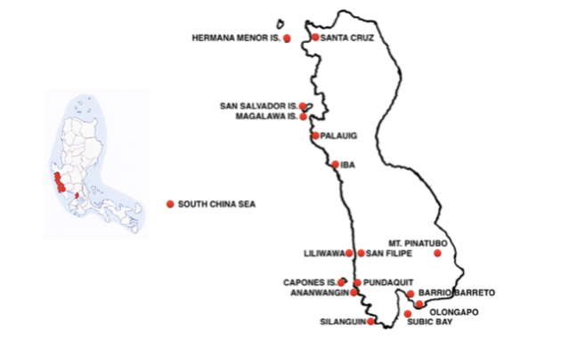
There are 18 TOP Beaches along Zambales’s 160 km / 100 m long coastline and they can easily be divided into 4 distinctive areas: the first in the south, deep in Subic Bay around and just north of Olongapo; the second in the southwestern tip, on the South China Sea; the third, halfway up the Zambales coast road, around Iba; and the last in the northwest corner.
DETAILS
The waterfront of busy Olongapo city has its own seaside gem, SBMA Beach backed up by a well maintained Boardwalk lined with dozens of resorts.
And yet only a few minutes north of it, over a small pine tree clad hill at the base of Subic Bay, there is a very different, much simpler experience to be had on at the beaches Barrio Barretto and at Baloy Long Beach.
All of these beaches are deep in Subic bay, and especially well protected from the South China Sea to the west, to provide calm conditions with no currents.
Leaving the glitz and comforts of Olongapo and the area to the immediate north at the bottom of Subic Bay behind and Moving just 30 minutes north takes beach seekers to a very different, much wilder experience.
Here the first port of call is San Antonio town (pop 35,000) at the head of the mountainous, pine-forested Redondo Peninsula which extends 9 km / 5 m south between Subic Bay and the South China Sea. The Redondo Peninsula is one of the rare areas in Zambales to benefit from the disastrous Mt Pinatubo eruptions as they dumped tons of ash, as much as 33 cm / 13 in, on its secluded southern coves transforming their previously rocky shores into a supple, shining piece of paradise surrounded by pretty agoho (sea pine) trees.
Just a few miles south of San Antonio is the small town of Pundaquit smack on the South China Sea coast. Pundaquit has a wide, inviting beach that is pleasantly swimmable most of the year while from June until October, there are usually strong waves that make it for a draw for surfing. Along the beach are a variety of low key resorts and canteens while there are other commercial establishments near the public market.
….. can’t recommend this place enough … just fantastic …. at night, it is very awesome if you have brought your own tent so you can watch the overflowing stars … magnificent sea view and islands on the horizon. … highly recommended to do island hopping to see the white sand shores and aqua marine waters ….
More importantly, Pundaquit is the starting point for a choice between island hopping to the Capones islands and to four coves running several miles southwards or a short drive north to a prized surfing beach.
The Capones are 3 small islands lying just 4 km / 2.5 m off Pundaquit that offer good snorkelling and dive sites, as well as great photo opportunities.
Capones is the largest of the 3 but still quite small – approximately 2 km / 1 mi long and only .5 km / .25 mi wide, at its widest point. This small island is consists of scenic steep cliffs surrounding a small patch of white sand and coral beach. It has a Spanish Lighthouse from the 1890s – now solar powered – located on the hillside near the western end of the island, a steep 15 minute hike from the beach.
Nearby is Camara Island, a short stretch of sand surrounded by rocky hills connected to an islet by a sand bar that is visible during low tide
Heading south of the Capones there is a choice of four beautiful coves – Ananwangin; Talisayin; Nagasa; and Silanguin – all with very limited electrical supply and only minimal accommodation.
Anawangin, the first of the coves heading south, just 30 minutes by boat from Pundaquit, is a lovely, large, crescent shaped cove with a pristine white sand beach and tall pine-like agoho trees flourishing all around it. Just behind the beach is a pine forest and a marsh, home to a number of bird species, from which there are natural springs feeding to the sea. The adventurous might want to approach the beach by a six-hour trek through the surrounding mountains. The cove has sari-sari stores, canteens and shower rooms for day visitors as well as a few cottages and camping facilities for overnight stays.
…. the beach is great … stargazing at night is a must, the lack of city lights makes the stars show up so brightly …
The second cove, Talisayin, is only a few minutes south of Anawangin and yet visited far less often, perhaps because its sand is greyish rather than white. But it has exceptionally clear water and is also an ideal site for stargazing. There’s a store in Talisayin Cove that sells a few snacks and drinks as well as three resorts that provide basic camping facilities, shared restrooms with running water and an open kitchen. Behind Talisayin Cove, there’s a small hill which can be easily climbed in less than an hour.
…… great place to stay with really beautiful view … I love the water here, it’s really clear! … camping and bonfire party at night …. amazing people who are so accommodating … great food! …. a quiet place to ponder and gain peace of mind. ….
A little further south of Talisayin is Nagsasa Cove, which is much deeper than Anawangin but similar in appearance, a beautiful white beach beneath steep hills with hiking trails leading up to viewpoints and, further on, to waterfalls.
Silanguin Cove, the last of the four coves, is much bigger and wider than the other three. It is located near the far southern tip of the Redondo Peninsula, back near the mouth to Subic Bay. The boat ride from the Pundaquit to Silanguin takes about an hour and a half. It has three simple resorts that provide shared facilities – bathrooms and shower rooms, kitchens and grills. There is no electricity, only solar power at night.The resorts provide facilities for kayaking and water sports. They have a few cottages and tents for visitors who want to stay overnight. Behind Silanguin Cove, there is a choice of two hiking trails: one an easy short walk through fields and riverbeds towards nearby waterfalls; the other a short but steep and unmarked trek towards the Viajero’s View Deck, which provides a wonderful view of the cove.
Back on the coast road, only minutes due north of San Antonio, are two more great beach towns, San Narciso (pop 30,000) and, across a river, San Felipe (pop. 23,000). Both offer a full range of facilities, from budget-friendly to high-end accommodation and cheap canteens to proper cafes and restaurants. But San Felipe is preferred by many because it is home to Liliwawa beach, which is described by keen surfers as “the closest surfing paradise to Manila”. As well as excellent waves, Liliwawa has a beach with fine gray / white sand with pine-like agoho trees along its shore side.
The next focal point for Zambales’s Top Beaches is its capital city, Iba (pop. 50,000). From Subic, it takes little more than an hour to reach the Iba, zigging and zagging 50 kms / 30 m along the coast road.
But there are all kinds of reasons for stops along the way, from excellent resorts at Cabangan, the halfway point, to a huge wildlife farm replete with Siberian tigers, Macaque monkeys, Brown deer, Wild Boar and Hawksbill Turtles, as well as a wide selection of birds, reptiles and flora at Botolan, quite close to Iba
… a top class wildlife sanctuary … this family run farm offers a pleasant
and interesting stay for people of any age ….
About 210 km / 150 m north of Manila, Iba is a bustling, go-ahead kind of place, with an increasing number of commercial establishments and financial institutions. For outdoor enthusiasts, it offers trekking to a number of local waterfalls, like the Tukal Tukal, Bibig Impiyerno and Sta Barbara.
But the main draw in Iba is the beaches to the north and south of the town, which are admirably clean due to the absence of industrial-polluting activities in the area. Investment in beachfront faculties have increased enormously during the last fifteen years until there are about 50 resorts in Iba. Most of the Top Beaches and resorts are situated close enough to the town centre to be easily reached by tricycle but there are half a dozen further north that offer an even quieter experience.
Beyond Iba Town, the attention turns to a series of off shore islands running up to the northern end of the Province. All of these islands can be reached quickly from small ports along the coast, in the shadow of Zambales’s towering Mt Tapulau, or linked together as part of an island hopping tour.
Three of the islands – Potipot, San Salvado and Hermana Menor – are very small and best suited to day time visits while the larger Magalawa, which can accommodate overnight stays.
Even though Magalawa Island is reasonably big, it would still take as little as two hours to walk around it. It can be reached in a mere 15 minutes by boat from Palauig, the first town after Iba. As well as having various small beaches without facilities, it has a distinctive L-shaped sandbar of amazingly fine white sand at one end of the island, with two resorts offering a variety of Nipa huts and camping.
….. we were planning to stay just one night but as soon as we saw the island’s creamy beige sand and emerald green waters and we knew we would be spending all of our 3-day, 2-night trip time here …
Close by Magalawa, is San Salvador Island, only minutes away from Masinloc town by boat. It is best known for the snorkelling at its giant clam sanctuary and the clear, shallow water around its lovely Babacala Sandbar, where a large, octagonal beach house sits on stilts to provide shade for tourists to lounge and have a picnic.
A little further north of Babacala is Potipot island, which can be reached by boat in 15 minutes from the beach and resorts at Uacon, close by Candelaria, the first town after Masinloc.
Finally, just north of Potipot, is Hermana Menor, off the coast near Sta Cruz at the very top of Zambales. This is a virtually unspoilt island with both a white sand beach and a sandbar but no stores or accommodation, only four cottages for daytime use and a grilling station.
….. a great place to visit..,,the water is so clear … cool!!!! … the white sand … it’s like you’re in Boracay on their famous beach ….
ZAMBALES’S TOP RESORTS
The Lighthouse Marina Resort, Olongapo
… great food and customer service … the ocean views are amazing … very clean place … greenery all around …. even has a large separate soaking tub ….
Arizona International Resort, Barrio Barreto
… spent a week and I can’t speak highly enough of the wonderful staff there, from the ladies in reception to the waitresses in the restaurant/bar … the restaurant is good and has a ton of choices …. a good view of the bay as well …
Amanente’z Beach Front Resort, Baloy Long Beach
… awesome … the rooms are so nice and clean, very good and friendly staff, foods are exceptional in taste … calm, very relaxing and you will always have peace of mind … the beach is so nice and natural, just a few steps from the hotel rooms …
Prince Ludwig Beach Resort, Pundaquit
… small, picture perfect resort next to the sea …. the owners are very lovely and take a lot of care … the huts are sweet and look like in a catalogue. … very good location … very nice and clean resort … the owners are the best ever!!!!! ….
Capones Vista Beach Resort, Pundaqui
… simple place but the outdoor options make for a great vacation … great food options … chance to visit the three famous nearby islands … great beach front with a spectacular view … beautiful resort architecture …
El Paradise, Silanguin
….. had an awesome time in El Paradise! … nice views and very affordable … it is clean and equipped with bathrooms and showers … offers snorkeling, stand-up paddle, hiking and island hopping .…
Kapitan’s Liwa Surf Resort, San Felipe,
… great experience … the staff are really kind and the food served is really worth the price … would pick this place all over again when we come back ….
The Palms Resort & Bar, San Narcisco
… the staff were super helpful, even drove us to gather food and other supplies …
Crystal Beach Resort, San Narcisco
… this is the nicest resort I’ve ever been to … the perfect place to go for surfing and soul searching … amazingly planned with a rustic theme … accommodation range from beachfront tents to fully equipped rooms … very photogenic place …
Casa Angelina, Cabangan
… superb experience and delish home cooked meals upon request! ….
Haven Beach Resort, Botolan
….. a peaceful and serene escape from busy life in the city … the water was crystal clear and the beach had fine grained sand … a lot of flowers in their garden … we will definitely go back! …. a cozy back-to-nature resort, its accommodation mostly made of bamboo, natural materials and thatched roofing ….
Ambay Beach Resort, South Iba
…. a beautiful garden oasis by the sea, Ambay feels like a deserted tropical island … greeting visitors is a pine tree at the entrance and various garden plants and vine cover the pathways … it’s relaxing and calming …
Tanyaw Beach Resort, North Iba
… exceeded my expectations in service … there have been renovations throughout the resort! … it’s has got service de luxe … the finishes of the ultra chic shower jets in my suite are perfect ….
Tammy’s Beach Resort, North Iba
…. nice resort right on the water … the views were gorgeous … best beachfront experience in Iba!!! … loved sunning by the lounge chairs and parasols … rooms were nice and clean and bigger than expected … an upscale resort with fab rooms and exquisite peace … has wonderful chairs with umbrellas a few feet from the water …
Palmera Gardens, North Iba
… the resort has two restaurants that serve a vast array of national and international cuisines … “Bahay Kubo” has a great view of the South China Sea and “Para sa Atin” is right at the beach front … the T-bone cooked medium well with baked potatoes, gravy and veggies is very, very good …
Potipot Gateway Resort, Unacon
…. amazing food and very hospitable staff … great pool … let me repeat that … amazing … food ….. worth the money and effort, even during Peak Season … better than what we expected ….
Dawal Beach Resort, Unacon
…. the best restaurant in the area with good food, a good ambiance and relatively low prices … large clean swimming pool as well as a clean beach…..
MANILA’S SEASIDE ESCAPES – DESTINATION 3: THE PROVINCE OF PANGASINAN
From Manila: Bus 220 km / 125 m (3.5 hr) north
to Dagupan town
Looks like …. …. a large bat heading due north.
“WHAT’S PANGASINAN GOT?”
Pangasinan is a huge province (15th out of 81), running 150 km / 100 m inland from the west coast all the way to the centre of Luzon, within shouting distance of the east coast. It has a relatively large population of 3 million people (6th out of 81) so it is quite densely populated (11th out 81).
Despite its size and population, it is easy to navigate because it consists of two distinct parts: the bulk of it, the bat’s right wing to the east, has major towns and excellent roads while the less developed remainder to the west – the left wing – surrounded by the Lingayan Gulf and the South China Sea provides a seaside experience
It sits in a strategic position in the large central plain of Luzon, the rice granary of the Philippines and rice is a major part of its economy. More surprisingly, the province is a major producer of salt. Indeed, the very name “Pangasinan” (pronounced “Pang-ASINan”) means “place of salt-making”. Production follows an ancient Egyptian tradition, mixing sodium bicarbonate with the seawater trapped in ponds until the water evaporates and only salt remains.
Pangasinan’s most popular city is Dagupan (pop. 170,000) on the Lingayan Gulf. The city is a major commercial and financial centre but is best known for its aquaculture. Crisscrossed by 7 rivers, it includes farms for oysters and sea urchins but above all hundreds of fish ponds for Bangus (aka Milkfish). It is a leading supplier of this national fish, which it claims is the tastiest in the country. To celebrate its importance, the city holds a Bangus Festival annually during the last two weeks of April.
For those who prefer meat treats, Dagupan offers two unique dishes: pigar-pigar, made out very thin slices of beef and liver quickly deep-fried, a treat that has its own festival; and kaleskes, a bowl of tender carabao’s meat mixed innards (“kaleskes” means “intestines”) in a hot broth – which is not for the faint hearted. Pangasinan is also known for its ceramic oven-baked native rice cake, calasiao puto, and delicious mangoes
Food aside, Pangasinan offers a rich mix of attractions, especially inland, to the east of Dagupan. The pretty Minor Basilica of Our Lady of the Most Holy Rosary, in the town of Manaoag, attracts thousands of pilgrims daily thanks to popular tales of its miraculous healing powers.
And further east, at the eastern edge of Pangasinan, near the town of Natividad at the foot of the Caraballo mountains, 60 km / 40 m (1.5 hr) from Dagupan, is another pilgrimage site to a statue of Christ the Redeemer standing on top of a short but challenging trek up Ayat ni Apo Jesus. Nearby a physical rather than a spiritual high is offered at the Sky Plaza, a high view deck in an amusement park on top of a hill offering visitors sweeping views of this beautiful region, which is home to some of the country’s most majestic waterfalls.
South of Natividad at Balungao, there is a Hilltop Adventure Resort combining nature with extreme sports and adventure activities – traditional trail walking together with a zipline and a bungee trampoline, all-terrain vehicle driving and mountain biking as well as a choice of hot and cold spring swimming pools.
In between these two towns, at Tayug, is Pangasinan’s most unusual attraction, a Sunflower Maze, the first ever in the Philippines. This huge labyrinthine maze created from about 8,000 sunflowers can accommodate up to 100 people. The site also has a Garden where people can pick vegetables and fruits in their own bayongs, Filipino bags made from weaving buri or pandan leaves.
Moving over to the extreme west side of the Province, the attractions range from St. James the Great Parish Church in Bolinao town, a Spanish colonial structure with an exterior made of black coral stones, to a trio of waterfalls along the Bolinao River, 30 minutes from the town.
…. the waterfalls are really beautiful …. a great place for jumping from high up into the refreshingly cold water …. its not crowded so you can really enjoy swimming …..
“WHERE ARE THE BEACHES?”
OVERVIEW
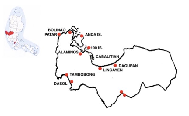
Only a comparatively small portion of Pangasinan, some 1/3 of its western wing, is bounded by water but that still leaves it with some 285 km / 170 m of coastline which harbours 20 Top Beaches, which are best divided into three distinct areas: those to the east and west of Dagupan, at the bottom of the Lingayan Gulf; those on the west side of the Lingayan Gulf, running north from Dagupan up to Bolinao town; and those running south from Bolinao along the Province’s west coast, facing the South China Sea.
DETAILS
The shore at the bottom of the Gulf runs some 50 km / 30 m (1 hr) on either side of Dagupan from San Fabian at the eastern edge of the province to Labrador in the west and much of it consists of wide, grey-sand beaches, with calm water for swimming and great sunsets.
There are some beaches close to the town itself, such as Bonuan Blue Beach.
….. an escape only a few minutes east of the city centre, situated next to the city’s Golf Course …
To the west of Dagupan, but still at the base of the Gulf, Lingayan City, the capital of Pangasinan, also has an extensive beach, Binnaley Beach
… Binnaley is popular for volleyball and skim boarding with kayak rentals for exploring the Gulf ….
But the area’s Top Beaches, all with a range of resorts, are slightly to the east of Dagupan, around Tondaligan, and further east still, at San Fabian. Many of these beaches are highly popular due their fine sand and plentiful coconut trees with the pretty Cordillera Central mountains in the background but they are sufficiently large to accommodate crowds.
Bolasi Beach, San Fabien
….. an ideal beach ….. vendors sell freshly-caught fish which can be cooked at nearby nipa huts to complete the seaside experience ….
From Dagupan the key route to the beaches on the west coast of the Lingayen Gulf is Regional Highway 5 which runs due north 90 kms / 55 m (2 hrs) to Bolinao at the top where the Gulf meets the South China Sea.
The beaches along this route divide into 3 main areas: those in the south, on the mainland around Sual (pop.35,000); those in the middle, around Alaminos (pop. 90,000), and on the Hundred Islands; and those in the north, particularly Tondol Beach, on Anda island.
First stop on this road is Sual, which sits snugly in a cove with a deep harbour offering a natural safe anchorage that made it a busy port of entry for the Spanish during two centuries of galleon trade. The first Top Beach here is Masamirey east of Sual:
…. perfect for white sands and splashing blue waves … play like a child on the knee-high, crystal clear waters. … it is good for snorkeling but there’s really no point in diving since everything is clearly visible from above the water.
From Masamirey, it is possible to go island hopping a few minutes south to wonderful beaches on Cabalitian Island
….. elegant simplicity with beaches, and its clear waters, shady
shores, and rocky mountains, but its serenity, and its unobstructed view of the horizon …
Back on the mainland, the road continues north to another Top Beach, Bolo, just 3 kms east of Alaminos,
…. If you just want to get away, relax and unwind, Bolo Beach might be just what you need …. peaceful and quiet, the water is clear and the views are great … you can rent boats if you want to see The Hundred Islands. …. best of all, Bolo Beach isn’t crowded ….
North of these first Top beaches on the Gulf’s west coast – 50 km / 30 m west (1 hr) from Dagupan – comes the area known for the Hundred Islands National Park in the Gulf just outside the city of Alaminos.
Only 45 minutes away by boat from Alaminos, this park stands out among the world’s natural wonders because it is so densely packed, with fully 124 pretty, small islands clumped together in a small (16 sq km / 6 sq m) sanctuary.The islands remain by and large virgin territory, only three of them slightly developed for tourism. Governors Island is the most developed.
… at the top of a 380-step climb there is a 550 m / 2,00o ft long zipline that connects to Virgin Island, which is also accessible across a 120 / 400 ft long pontoon bridg …. has a viewing deck which provides spectacular views of the Hundred Islands National Park ….
Other islands of note include Quezon, where there is snorkeling at the giant clam farm; Marcos, popular for cliff diving; and Children’s, with a child friendly beach. Among the lesser known islands with no amenities are Romulo, which has only a small beach but near white, soft, powdery sand, and Lopez Island
….. Lopez was so clean …. with fine white sands, clear water, and large rocks for shade …. like a private island … only ever a few people there.. ….
Some 35 km / 20 m (1/2 hr) north of Alaminos and the Hundred Islands on RH 5, near the top of the Gulf coast, is the turn off for Anda Island, which is larger than all the Hundred Islands taken together.
Also known as Cabarruyan Island, Anda is most often visited for its excellent Tondol Beach which some feel is “the best beach in the Philippines”. It is situated on Anda’s east coast, a long way across the top of the island which means it is well off the beaten track for crowds.
…… absolutely worth the effort … so serene with clear blue water … amazingly fine white sand at low tide … even at high tide when the sand is submerged the maximum water level is up to waist that makes it a child friendly beach … it isn’t crowded …. it’s like it’s your own private island… during a summer season weekend, we encountered only 2 tourist boats during our island hopping …
Despite the convenience of the beaches around Dagupan and the beauty of the beaches north and south of the Hundred Islands, the Province’s west coast facing the South China Sea is Pangasinan’s peak section for Top Beaches, stretching for x? km / x? m southwest from Bolinao (pop. 80,000), from the most famous beach, Patar in the north, to the more remote, far less developed beaches in the south.
Bolinao has its own popular beach, Long Beach, just to the west of the town:
…. the area has lots to offer so two nights is the bare minimum to stay just to cover the falls and underwater caves and tour the private island of the Birdland resort …
And then, only 10 km / 7 m south, comes the beginning of Patar Beach, which fills the coast for the next 10 km / 7 m.
….. the so-called Boracay of the North thanks to its white sand …. ….. the creamy white sand of this beach gently slopes into the sea making it an excellent swimming beach … an amazing beach, fine creamy sand, coral, fish, crystal clear water, rock formations, and golden sunsets …. largely undeveloped but there are some cottages/nipa huts not too far away from the beach ..… Enchanted Cave halfway down Patar Beach, like a huge coral reef that emerged from underwater.
Patar Beach is anchored at its south end by the 100 ft high Cape Bolinao Lighthouse. Built in 1903 it is one of the country’s most important lighthouses and one of the highest, with a 140 step spiral staircase. From the lighthouse, the road turns inland slightly for a few kms to pass behind the Ban National Forest Preserve Park and the tiny but perfect Surip Beach,
…… fantastic place … bright yellow sand beach … very serene … clear waters good for snorkeling … we had the entire beach to ourselves …..
From Surip, the coast road heads further inland to join the main highway, meaning the remaining Pangasanin beaches to the south are far more remote and, consequently, far less developed. First up is Abagatanen Beach on the northern edgesmall Agno Bay halfway down the west coast.
…. undeveloped yet but it’s the most AWESOME beach I’ve ever seen …. very beautiful beach with rocky cliffs … perfect place to visit with family or friends … such a beautiful place … the water was so clear and blue … the way there is sand everywhere between the beach and the river was so stunning …
South of Abagatanen are Sabangan Beach, well regarded for its diversified marine life, and Bunga Beach, known for its white sand and the shade offered under the famous geological formations that resemble giant mushrooms or rounded umbrellas.
Further south still, on the bottom half of the west coast, jutting out into the south China Sea, accessed from Burgos, is Cabongaoan Beach.
…. quite remote… the ride from Burgos isn’t short … still, once you arrive, it is all worth it … less developed than most beaches in Pangasinan … its white sand and long shores make it the perfect beach for snorkeling, jogging, or just, unwinding … I really love this paradise… white sand, blue ocean, and blue sky … just wow!… I feel like I’m free … I totally forgot my problems and just enjoyed the moment … a lace I’ll never forget ….
South of Cabongaoan is Dasol Bay, a big bite that forms the very southern end of Pagasinan’s west coast. Top Beach here is the secluded, south facing Tambobong, on the very northern edge of Dasol Bay –
…… if you’re looking for a clean, white, budget friendly beach this is the place to go … the big plus is the place is not crowded even during summer … island hopping to super beautiful Colibra Island due south was the highlight …. we were in awe of the beauty of the beach there …. was like going to El Nido and Boracay all in one place. …. there is a great beach at the nearby Balinmanok Cove where you can snorkel around a
Taiwanese shipwreck …
Beyond Tambobong, there are more good beaches running south along the shore of the wide Dasol Bay itself, served by the last of Pangasinan’s resorts.
PANGASINAN’S TOP RESORTS
Mayos Beachfront Resort, Bonuan
…. enjoy the experience of living in a simple provincial style ….
Hollywood Beach Cottages, San Fabian
…. checking in was extremely easy … the owners are very friendly and accommodating … enjoyed the seafood bbq … I love the little nook where there are books to read …. family atmosphere with the videoke until 10pm only …
Sierra Vista Beach Resort, San Fabian
…. the beach is good and there are 2 swimming pools – one for kids and one for adults … there are small cottages near the beach for guests to use for eating ….
Masamirey Cove Resort, Masamirey Beach
…. a paradise! …. the place is very relaxing … the facilities are well maintained and very clean …. people are so nice, customer service is excellent … nearby islands are a bonus for your island-hopping thrills.
One Sophia Beach Resort, Bolo Beach
…. the owner is so kind … I booked one night only but decided to stay 2 …. strongly recommended if you want to feel cosy and relaxed …
Nautilus Islands View Lodge, Alaminos Wharf
… beautiful property, well manicured … they are very friendly and go above and beyond to make your stay comfortable … food was excellent … staff picked me up at the bus station ….
Big Brother House, Governor’s Island ….
… can accommodate 8 people for only PHP5,000 per night but there are also 11 gazebos for rent throughout the island for only PHP600 per day.
Sarmiento Beach House, Tondol Beach
…. the best place to stay on Anda Island … the facilities are clean and the staff are accommodating and polite … the food was the best … my fiance and I extended our stay because we simply fell in love with the place …
Birdland Beach Club, Long Beach
… by far the best resort in this region …. with great views and service … very unique in design and architecture …. I love the bamboo pathways … we stayed in one of the tall bamboo houses which nestled right over the water … fantastic place to holiday with very stunning views … they have over 50 activities at the resort to keep you and the kids busy . … true paradise … so quiet, so isolated and just perfect to relax … the place is a marine sanctuary so the waters are protected and very clean for all types of water activities including swimming. We really enjoyed our family outing here for the weekend …
Puerto Del Sol Beach Resort and Hotel Club, Patar
… easily met and even exceeded our expectations …. room was clean and well maintained …. staff are polite and customer service oriented … my son really enjoyed the beach because of low tide … great choice if you are looking for a place to unwind, relax and be away from city life but you don’t have the time and money for a flight … I highly recommend this place … been going here once or twice a year since 2013 …
Veue Beach Cabins, Patar
… I fell in love with this place as soon as we first came … everything is well designed, well thought of and well maintained …. …. I’m quite hesitant to share my love for this place because I love how private it is … love how the beach is so nice and quiet … love the cabin interiors and how they all have a view of the sea. ….
Treasures of Bolinao, Patar
… pool is superb … good food, white sand and friendly and courteous staff … its relaxing, quiet and peaceful … I always go back every year ….
Roven’s Place, Cabongaoan Beach
…. if you want to have quality time with your love ones, this place is perfect … nice beach and accommodation … here you can focus on relaxation … auburn and white sand, clean and beautiful panorama …
Villa Toledo, Cabongaoan Beach
…. I think this is one of the most private locations along the beach … the best place to stay at Cabo beach … a great view of the beach both in the early morning and most especially during the evening for sunsets …
Rains Resort, Tambobong Beach
… one of the best places in Pangasinan … everything about it is perfect … we had a great time and we’re coming back soon … thanks Greg and Mae for making our stay a memorable one … this place is a good jumpstart to island hopping as motorized boats are aplenty …
Matabang Beach Resort, Tambobong Beach
… its a serene place … excellent accommodation … the beach is white … love this crystal clear beach … the contour of the seabed is even, no current down below ….
Rosmin Nature’s Hub Resort, Dasol Bay
…. best place to stay in Dasol to experience great customer service and to explore nature … the café serves Pangasinan’s popular danggit and daing na pusit with all-day breakfast. Room space is right and the temperature is cool due to its being at the riverbank …
MANILA’S SEASIDE ESCAPES – DESTINATION 4:THE PROVINCE OF LA UNION
From Manila : Bus 270 kms / 175 m (5 hrs)
to San Fernando, capital of La Union Province.
Looks like …. …. an Eastern Island head facing east.
“WHAT’S LA UNION GOT?”
La Union is an extremely small province (69th out of 81) yet has a significant population of 800,000 (36th of out 81) meaning it has a high density (9th out of 81)
Despite being located so far north of Manila – at the beginning of northern Luzon – it is still easy to reach because the MacArthur Highway from the capital runs straight to it.
Being small, essentially rectangular and squeezed by the Cordillera mountain range to the east, the province is also extremely easy to explore, with a single main road, the MacArthur Highway, running along the 90 km / 55 m long coast from its southern fringe to the north.
The economy is diversified with service, manufacturing, and agricultural industries spread throughout the province, including an interesting range of simple items from antique-finish furniture to hand-woven blankets (inabel).
Prominent foods include rice wine (tapuey) and sugarcane wine (basi); and pebble stones (more on that later).
However, the most famous La Union product are “Walis Tambos” (aka Boyboys), the whispy soft brooms which are found in virtually every home in the Philippines. They are made mainly in the Province’s eastern towns, in Burgos and Bagulin, and in a few mountainous parts of San Fernando, where the essential ingredient, Tiger Grass, is abundant. To make the brooms the Tiger Grass flowers are dried, then boiled – twice – and then shaken to make sure that no pollens remain. To make the increasingly popular coloured Boyboys, the flowers are boiled a third time with dye.
The provincial capital, San Fernando (pop 130,000), midway up La Union’s short coast, is the financial, industrial and political center of the province, the Port of San Fernando an increasingly active shipping point and the former American airbase Wallace Air Station on the coast next to San Fernando, has been converted into a business and industrial area that helps to facilitate more commercial activity.
Being so compact, all of La Union’s top attractions can be easily visited. One on a hillside just outside San Fernando is the towering Taoist Ma-Cho Temple, crowned by an unusual spider-type dome, the Majestic Five Door Gate, with its interior filled with ancient Chinese decorations. The city also has a vast (10 hectare) Botanical Garden displaying flora and fauna that are indigenous only to the Philippines in different pavilions – a Fernery, Palmery, Fragrance Garden, Sunken Garden, Evergreen Garden Shade Garden and an Arid Paradise
In Bauang, just south of the capital, the grape farms encourage visitors to pick and bring their fresh harvest home as pasalubong.
Several of La Union’s most unusual attractions are in the north, at the town of Luna, which is known as the Pebble Capital of the North because of its many pebbled beaches and stone-picking industry. One attraction here, Bahay Na Bato, on the most beautiful pebble beach in Luna, is a rest house built with stones found on Luna’s beaches, has stone sculptures made by Korean artist, Bong KimIn inside and around the grounds.
A few hundred meters away along the pebbled beach stand the Luna Baluarte or Watchtower, a Spanish fortress that was used to look out for pirate attacks.
The top natural attraction close to San Fernando is Tangadan Falls, which has a large swimming pool with bamboo raft rides to the main cascade for a cool shower as well as smaller waterfalls above and below suitable for cliff diving.
“WHERE ARE THE BEACHES?”
OVERVIEW
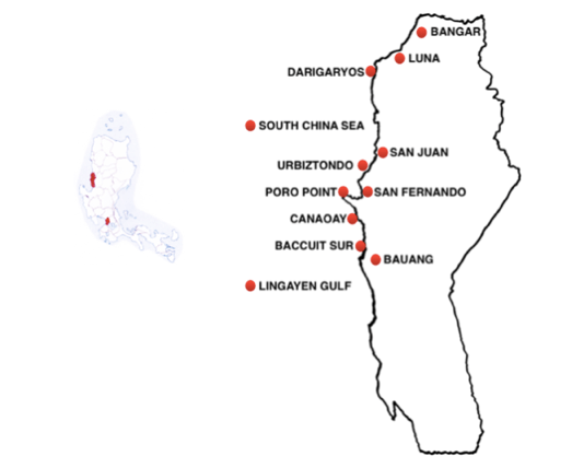
La Union’s 6 Top Beaches are concentrated on a short (20 km / 15 m) long strip in the centre of the province ’s 90 km / 55 m long coast, to the north and south of the capital San Fernando, and all easy to reach from the main highway.
DETAILS
La Union’s southern border begins deep in the Lingayen Gulf to the east of Dagupan but its The Top Beaches only begin half up the Province’s coast, near the mouth of the Gulf.
Here the first port of call along the beach road, the MacArthur Highway, just north of Bauang town, is a 6 km / 4 m long strip fine sand broken into a quartet of beaches in quick succession: Baccuit Sur, Baccuit Norte, Paringo and Pagdalagan Sur. The best sand here is at the beginning of the strip, on Baccuit Sur, as further north many resorts have built sea walls that significantly reduce the size of the actual “beach”.
Further north of the Bauang beaches, La Union’s coast suddenly juts out into the South China Sea to form Poro Point and a minor road departs from the main highway to track this protuberance, running past two admirable beaches Canaoay and Acapulco. …. awesome clean white sand beach …. breathtaking sun sets
At far end of Poro Point is Bay Walk Beach dominated by the famous Thunderbird Resort. San Fernando city proper spreads up the coast just inland beyond the Point.
Just a few minutes north of San Fernando, at the town of San Juan, lies the Province’s most cherished asset, Urbiztondo Beach. For people who enjoy riding the waves this is “The Surfing Capital of the North”.
Foreigners started surfing here in the ‘80s and today it is a chill vibe getaway, good for both beginners and advanced surfers with reliable swells almost all year round. In the best conditions, the waves here can be up to 5 m /15 ft high and 300 m / 1,000 ft long. Two major surfing competitions are held annually, including the international Mabuhay Cup, the longest running longboard competition in the Philippines.
… it’s been a year since my last visit to Urbiztondo but I still can’t get it out of my head. …. the coast has turned into a beach town, with a number of restaurants mushrooming just along the main road and accommodation options sprouting by the beach ….
Non-surfers looking for somewhere new in La Union can travel further north to visit Darigaryos Beach, at Luna, near the top of the Province.
….. small but nice fine white sand beach in a cove … the sea is so calm….
not crowded even in summer ….
LA UNION’S TOP RESORTS
Lafaayette Luxury Suites Resort, Baccuit Sur
… place was lovely … pool was good and the beach lovely … perfect for family and friends … quite romantic for love birds … an absolutely beautiful view as well as good service … our experience there was a delight …
San Luis del Mar, (Baccuit Norte)
…. foreign friendly … great place for a day or a week stay … friendly and courteous staff … got to get away and chill? Here’s the best spot to take a break …
White House Beach Resort, Paringao, MacArthur Highway
…. you can see the infinity pool from the room and see the beach right behind the pool … the rooms are very clean … the bed is especially comfy, so I almost wanted to sleep all day …
China Sea Resort, Paringao, Bauang
… great dining area overlooking the ocean … the pool is nice and there is a stair directly down to the ocean, which comes right up to the resort … it’s a very relaxing resort located in a quiet area away from the noise of San Fernando …
Villa Estrella Resort Hotel, MacArthur Hwy. Paringao, Bauang
… big rooms … quiet place with a nice indoor pool …
Aureo La Union, Canaoay
… the villas are spacious and well kept … the food is good and the staff are all polite and accommodating … beautiful pool and quite good beach that is also toddler-friendly.
Sunset Bay Resort, Canaoay
… we had a wonderful stay! … the rooms were clean and neat … it made me feel like home … the food was exquisite! I love it …
Thunderbirds Resort-Hotel, Poro Point
… this is a Santorini-inspired resort with white-washed buildings and blue domes in a gorgeous cliff-top location, facing a serene sunset view … infinity pools are generously designed … good place for a luxurious stay or just a romantic dinner …
P and M Final Option Beach Resort, San Juan
… as good as they come – a beach front resort with good views … rooms situated in different places with garden, beach and pool views.
Kahuna Beach Resort and Spa, San Juan
… beautiful beachfront resort … staff are nice and friendly … the best rooms are themed uniquely, like the 40 boutique Balinese – inspired cottages and the ocean villas that are directly peering out into the beach … the Filipino and Balinese cottages are designed with native grass roofing made with natural materials but are still offering high features …
The Little Surfmaid Resort
…. I’ve stayed here 5 times now and will continue to do so every time I go to La Union.
Isla Bonita, San Juan
…. I admire the ambiance and view of the place and the beach. Very nice and comfortable accommodation …
Flotsam and Jetsam Artist Beach Hostel,
….. really nice place with a very chill vibe …. it’s a good place to have fun and just chill … artistically beautiful … we got the bedroom with a queen bed and balcony, and we wish we booked it for longer! … aside from being very clean and comfortable, every little detail was thought out, from the hangers, hooks and racks to the bedside lighting.
Awesome Hotel,
… has an excellent location … we had a 4-hour drive from Manila and arriving at the resort, experiencing the warm welcome of the staff, meant it was definitely worth the trip …
Noble Tower Resort, Luna
… near Darigaryos Beach … the tower gives you a very beautiful view of the ocean and sunset ….
MANILA’S SEASIDE ESCAPES – ROUTE 5 :
THE PROVINCE OF ILOCOS SUR
From Manila: Bus 400 km / 250 m (8 hrs)
to Vigan, capital of Ilocos Sur
Looks like …. …. a very small animal with its nose pointing north
“WHAT’S ILOCOS SUR GOT?”
Ilocos Norte is a smallish province (51st out of 81) with 700,000 inhabitants (42nd out of 81) so it is quite densely populated (33rd out of 81).
It consists of two distinct parts: the bulk of it, at the southern end, sprawls inland and downwards while the much smaller, narrower top portion hugs the coast, rising up like a wisp of smoke.
Its landscape is low and undulating near the coast but mountainous inland, with elevations ranging up to 1,700 m / 5,600 ft.
There is a patchwork of major roads in the bulkier southern area but the main route serving the whole province is the MacArthur Highway which runs along the coast for 130 km / 80 m (3 hrs) from Tagudin (pop.40,000) in the extreme south through the capital Vigan (pop. 60,000) in the narrow, upper portion to Sinait (pop. 25,000) at the northern edge.
Vigan, the province’s capital, is located on the mouth of the Mestizo River. It was founded in 1574 by the Spanish conquistador Juan de Salcedo Vigan and early on vied with the city of Intramuros (Manila) in terms of both importance and gentility.
Its initial prosperity came from trading with the Chinese and the Japanese who brought fine silks, ivory works and inlaid furniture. Later, in the 19th century, Vigan began to trade with Europe, sending ships bearing indigo for the textile mills there in return for various European products – from dinner ware to statuettes of brass and iron – that enriched the fine homes of Vigan’s affluent citizens.
Today, the province’s premier money crop is a far remove from textiles – Virginia leaf tobacco. Candon City (pop. 60,000), once a small resort town on the coast to the south of Vigan, is “The Tobacco Capital of the Philippines,” the country’s largest producer of the Virginia variety.
Candon is also famous for making the world’s heaviest and largest kalamay, a snack made from sticky rice, coconut milk and sugar.
The province has many notable churches, beginning with Our Lady of the Assumption, a UNESCO World Heritage Site inSanta Maria (pop. 30,000),
….. a beautiful baroque church at the top of a hill with a nice view of the town… the brick facade is really incredible and the clock tower has a very Instagram look ….
But its undisputed star attractive is its four centuries old capital city, Vigan, also a UNESCO World Heritage Site. Its layout and architecture, reflecting cultural elements from the Philippines, China and Europe, is the best-preserved example of a planned Spanish colonial town in Asia. Heritage houses dot the whole of Vigan but Calle Crisologo is the most densely preserved and their focal point.
….. the beautiful antique buildings and houses on this heritage street really brings you back in time, especially in the evening when one can ride a horse drawn chariot along the cobblestone roads full of yellow coloured street lights …..
One example on Calle Crisologo is the Sequia Mansion, majestic,19th-century house named after the wife of Elpidio Quirino, the 6th President of the Philippines,, who was born in Ilocos Sur. Made with thick brick and stone walls and painted wood, it has grand, opulent rooms full of period furnishings & art.
Besides its fabulous colonial architecture, Vigan is famous for its empanada, a Spanish Era delicacy made out of cabbage, egg yolk and ground pork.“WHERE ARE THE BEACHES?”
OVERVIEW:
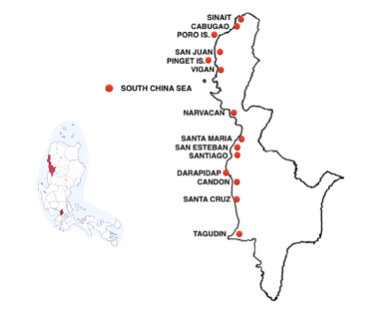
There are at least 12 Top Beaches along Ilocos Sur’s 150 km / 100 m coastline.
DETAILS
Ilocos Sur’s notable beaches start with Darapidap Beach, a long wide stretch of good sand at Candon, “The Country’s Tobacco Capital”. But the Top beaches start further to the north around Santiago (pop. 20,000), already a third of the way – (40 km / 25 m) – up the coast (1 hr), starting with Butol Beach, just south of the city.
Next, the star location in this area, is Sabangan Cove, (also known as the Santiago Cove), to the north of Santiago
… a small patch of paradise … dubbed “Boracay of Ilocos Sur” because of its kilometre long white sand beach and calm waters … the cove is protected by reefs so strong waves are calmed down before reaching the shore … rows of the colourful cabanas along the shore with eateries or stores selling sea products … in the evenings, electric lighting illuminates the beach …
Beyond Sabangan Cove, there is a trio of fine beaches, Apatot, San Esteban and Suso, along the 15 km / 10 m (20 min) stretch of coast running north to Santa Maria.
…. Suso is a neat eco-tourism spot … great discipline for maintaining the environment ….. crystal clear waters …. great for hanging out with family …. safe to camp out on the beach as there are barangay “tanods” around at night ….
Nalvo Beach is a particularly pretty strip of sand at the north end of Suso Beach.
After Suso Beach, north of Santa Maria, is a good beach at Narvacan called Sulvec, after which there is an unremarkable stretch of coast for 40 km / 25 m (1 hr) up to Vigan and another series of beaches running along the 40 km / 25 m (1 hr) stretch north to Sinait (pop. 20,000), the most northernly town in the Province.
The first beach of note here is Mindoro, outside Vigan.
…. you really must try to visit this beach just 15 minutes from Vigan … so beautiful …. greyish green clean sand shore …
North from Vigan the first important beaches are on Pinget Island,which are particularly easy to reach because this “island” is actually an peninsula jutting out from the mainland into the sea and only becomes an island during high tide.
North of Pinget, Poro Island (aka Salomague Island and Cabugao Island) is a proper island with at least one lovely beach. It can be reached in 10 minutes from Sabang Beach or from Salomaque Harbour, south of Sabang Beach, both of which are just a few minutes due west of Cabugao.
… one of the best choices for its wonderful white sand beaches …. not crowded and no commercialized resorts, only the island and the white sand beach …. … a small paradise …. so quiet and peaceful, we could hear the sounds of many different birds. … I was really amazed with the crystal clear water … many different kinds of fish can be seen even in the shallow part of the sea just wearing goggles.
Just off the highway in the first cove a few minutes north of Cabugao, is the highly ratedPug-os Beach,
… its half-kilometre sandy cove ideal is for swimming … a handful of resorts as well as inexpensive native cottages …
Finally, a further 15 km / 10 m (30 minutes) north, on the north side of Sinait, is the lovely Cabangtalan Beach.
… the beach is beautiful with pale sand … D’Lighthouse White Beach” and “The Boracay of the North” … clean and not crowded … …. the people are great … …
TOP RESORTS
Ursa Major Beach Resort, Apatot
… the whole experience was just wonderful….
Ilocos Marina Resort, Sabangan Cove
… no reviews ….
Punta Del Mar, Mindoro Beach, Vigan
… offers one of the best views for both sunrise and sunset … there is a good view of the beach and of the mountains to the west … there is a floating restaurant and pool ….
Pagsanaan Beach Resort, Mindoro Beach, Vigan
… a perfect weekend getaway … a place to relax, contemplate & enjoy the beauty of nature … clean & with good service… quiet & peaceful with no congestion …
Cabugao Resort, Pug-Os Beach
…. quiet … pool in midst of tropical garden … fine white sand beach …
MANILA’S SEASIDE ESCAPES – ROUTE 6:
THE PROVINCE OF ILOCOS NORTE
From Manila: Bus 480 km / 300 m ( 9 hrs)
to Laoag, the capital city of Ilocos Norte,
and then 75 km / 45 m (1.5 hrs) to the town of Pagudpud.
Alternative: Fly to Laoag and then bus to Pagudpud
.
Looks like … another small animal, its snout to the north.
“WHAT’S ILOCOS NORTE GOT?”
Roughly rectangular in shape, Ilocos Norte is relatively small in size (38th out of 81) but has a small population of 600,000 people (48th / 81) which means that it is comparatively sparsely populated (52nd / 81).
Despite is smallness and its relatively remote location, on the extreme northwestern edge of Luzon, Ilocs Norte is one of the richest provinces in the Philippines, with one of the highest levels of income per capita.
It also has an appealing tropical climate, despite its northern position. The average annual temperature is near 28C and it enjoys an extensive 6 month long “dry” season from November to April.
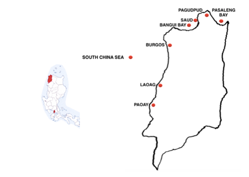
It tends to be hilly to mountainous inland – rising up to Mount Sicapoo (2,350 m / 7,700 ft high – so its single main road runs some 100 km / 60 m along its more level western coast from the small southern town of Paoay (pop 25,000) and due north 20 km / 15 m ( 30 mins) through the capital city Laoag (pop. 110,000) then virtually without stop 75 km / 45 m to Pagudpud (pop 25,000) at the very top of the Province.
Ilocos Norte has a dynamic economy including agriculture – from rice and garlic to fruit and tobacco; fishing, particularly tilapia; and livestock, such as swine and cattle. Its cottage industries cover loom weaving, furniture, jewellery, garments and ceramics. It is also one of the few provinces in the Philippines that generates renewable energy. Its northern position makes it ideal for wind power generation and there is already a large wind farm, consisting of 20 tri-blades, each 70 m / 230 ft high, spread in an arc along Bengui Bay at Burgos, north of Laoag. This wind farm is the first of its kind in Southeast Asia and more are planned for Ilocos Norte.
Among the most popular attractions in Ilocos Norte is the 300 year old St Augustine’s Church, in the southern city of Paoay, built by Augustinian friars using coral bricks for its massive walls and the enormous buttresses on the sides and at the back.
… a wonderful historic church .… a fantastical fusion of local and baroque architecture. ….… particularly powerful example of Spanish era architecture unique to the northern Philippines ….
Just outside Laoag the Lapaz Sand Dunes offer a unique desert-like environment with dunes created as a result of the interacting wind, sea, and river ranging up to 30 m / 100 ft high.
Further north, 55 km / 35 m (1 hr) from Laoag, at Burgos, there two very different kinds of monument, both offering panoramic ocean views.
The first, the 66 ft high Cape Bojeador Lighthouse was established in 1892, during the Spanish Colonial perod, and the second, the dramatic Kapurpurwan Rock, a strange geological formation by the beach, at the southern end of Bengui Bay
From Bengui Bay it is only another 35 km / 20 m (45 mins) north to the province’s northern tip, the top left side of Luzon, and the town Pagudpud (pop 25,000), which is surrounded by 210 sq km / 80 sq m of flat coastal land giving over to mountains and valleys. Given the surrounding landscape, natural attractions dominate around Pagudpud, all within easy reach, including, off the coast to the north, the Dos Hermanos Islands, unusual twin rock formations; to the east, Bantay Abot Cave, a huge hole that was created in the centre of a verdant hillside by the sea when it was struck by an earthquake in the 80s; and in a bay to the southeast, the bell-shaped Timmangtang Rock
Slightly inland to the south a 30 minute trail from the highway through tropical forest leads visitors to the towering Kabigan Falls and further south the more remote 12 m / 40 ft high Anuplig Falls with two basins ideal for swimming.
But surprisingly high on the list of sights for many visitors is a distinctly manmade project, the Patapat Viaduct Bridge, 20 minutes south east of Pagudpud, a 1.5 km / 1 m long bridge built fully 30 m / 100 ft above the cobalt waters of the Pasaleng Bay to take the road away from the green coastal mountains of the Cordillera to avoid landslides.
“WHERE ARE THE BEACHES?”
OVERVIEW
Despite its small size, Ilocos Norte has an extensive coastline where its 5 Top Beaches are easily divided into three main areas: the first in the southern end of the Province, north and south of the capital Laoag and Paoay; then in two areas in the extreme north, to the left and right of the town of Pagudpud.
DETAILS
There are many small beaches all along the Province’s long coast, starting in the far south with Nipa Beach, near Paoay.
….…. famous for its clean and blue water …. the whole beach has tall trees providing good shade .…
But the Top Beach in the southern area is Calayab, just south of the Laoag. It is home to the best Province’s resorts, including the world famous Fort Ilocandia, which has its own casino.
But the main Beach draw in Ilocos Norte is much further north at the very top of the province, with beaches on the tip north of Pagudpud town and in bays in a very compact area either side of town.
To the west 10 km / 6 m (15 mins) from Pagudpud (at the top of the right hand side of the wide Bengui Bay) is excellent 2 km / 1.5 m long Saud Beach –
….. a long curving pristine white sand beach lying on the magnificent blue and crystal clear waters of the South China Sea … at the south endTerra Rika Beach is more peaceful than other beaches …
On the other side of the point, east of Pagudpud, lies the wide Pasaleng Bay and the astounding Pannzian Beach (9 km / 5 m long) with many coves and beaches.
… a long stretch of powdery white sand beaches and crystal clear blue waters.
Pannzian starts with the Blue Lagoon at the top, not far east from Pagudpud.
… easy to see why it is called Blue lagoon, as the water is very blue …. also known as Miara-ira Point Cove …like a giant swimming pool when looked at in a map …
TOP RESORTS
Century Gardens Hotel, Pasuquin
… super staff … very clean rooms and stylish CR …. swimming pool with pool seats …. best of all THEY HAVE FIBER OPTIC WIFI with NO PASSWORD … we originally booked only 2 nights but ended up staying for 4 …
Fort Ilocandia Resort & Casino, Calayab Beach, south of Laoag
… their rooms and courtyard looked so beautiful – like you had been transported to Seville …. I love love love this place … I hope to move to the Philippines soon and work here … awesome property and location …
Playa Tropical Resort Hotel, Currimao
Seems like only resort south of Fort Ilocandia ….. Q. Where’s the beach????
… nice hotel close to a beautiful wide beach … this place is just absolutely amazing! … …. Balinese-inspired beachfront getaway leading to a nice infinity pool … villas have their own private pool … I think the best sunsets happen here! …
Kingfisher Resort, Pagudpud
… I love this hotel … this was my second time in Pagudpud and the place never fails to impress me … the hotel is located in a very quiet area … it’s hard to find but the long trip is worth it …
Alta Vista Ilocandia, Pagudpud
… amazing location with amazing view … very spacious, clean resort where the staff are very polite and respectful, always smiling and helpful … relaxing place … away from the main resorts of Pagudpud, this place is quiet, exclusive …
Evangeline Beach Resort, Saud Beach
… I love this place … the rooms are big … it’s like a native home … homey and they have a small pool … I’ll call it cozy. They also have a restaurant which serves great tasting food … best of all, their staff are VERY FRIENDLY …
Saud Beach Resort, Saud Beach
…. on a sandy stretch of beach this relaxed hotel amid leafy gardens i … I love how powdery fine the sand is … some of the finest sands I’ve ever been too … the food is delicious and the service very good …
Apo Idon Beach Hotel, Saud White Beach Cove
… a great place to stay and relax! … a classy blend of tropical and Mediterranean elegance … well-furnished rooms …
Terra Riki Dive Resort, South END of Saud Beach
… a good place to meditate and relax ….
Casa Consuelo, Blue Lagoon
… clean rooms and very accommodating staff … clean beach … the seafood platter is great! … I was amazed by their dishes because they’re authentic and homemade … every corner of the place is worthy of an instagram post …
Kapuluan Vista Resort Hotel, Blue Lagoon
…. ambience is great and friendly staff … a scenic and serene place … the food is great … fresh and organic food and beverage that is good and healthy … we stayed in a room with a mini garden in our very own bathroom …
Hannah’s Beach Resort, Blue lagoon
… huge … 7 hectares of well-maintained hillside gardens … five pools, two bars …. they had fascinating character statues all over the place … the beauty and service here made the long trek from Manila worth it …. my highlight was the beach side massage at sunset. ….
Pannizian Beach Resort, at the very bottom of the bay.
…. family run … an ideal place to disconnect from all of life’s distractions and just enjoy nature at its best…. very serene and quiet … the regional food is so delicious that you’ll look for it when you go back to Manila …
MANILA’S SEASIDE ESCAPES – ROUTE 7:
THE PROVINCE OF CAGAYAN
From Manila: Bus 640 km / 400 m (13 hrs)
to Santa Ana (pop. 40,000)
Alternative: fly 1 hr (480 kms / 300 m)
to Tuguegarao, the capital of Cagayan,
then bus 160 km/ 100 m (3 hrs) to Santa Ana.
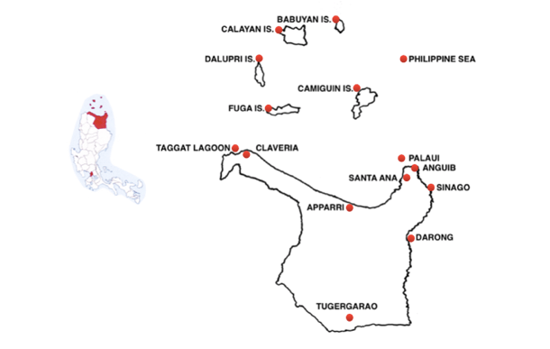
Looks like ….. … a pistol pointed west
“WHAT’S CAGAYAN GOT?
Cagayan is a huge province (5th out of 81) but has only 1.2 million people (22nd out of 81) so it is sparsely populated (63rd out of 81).
It is irregularly shaped – like a pistol pointing west. It spreads some 150 kms / 90 m (4 hrs) across the top of Luzon, from Calveria (pop 30,000) in the west (the tip of the pistol) to the promontory (the pistol’s hammer) around Santa Ana (pop. 40,000) to the east.
It has an unusual northern boundary, the Babuyan Islands, which start 60 km / 40 m north of the mainland.
The bulk of the province – the pistol’s grip – is bounded by mountains: on the west by the Cordillera Mountains, while the eastern coast is dominated by the Sierra Madre mountain range – the highest elevation is Mount Cetaceo (1,800 m / 6,000 ft) – and the south by the Caraballo Mountains.
The central area between the mountains varies from hilly to low in elevation, around the Cagayan, the longest river in the country, flowing from the province’s capital, Tuguegarao (pop. 160,000), in the extreme south 160 kms / 100 m north to the sea at the northern town of Aparri (pop. 65,000).
Cagayán was one of the first areas of the Philippines to be explored during the Spanish Colonial Period, with a mission founded by Dominicans at Tuguegarao in 1604.
The city has suffered during modern times: in December, 1941, it was occupied by the Japanese and in December, 1944, U.S. Air Force planes began bombing the Japanese occupiers, reducing the city to rubble. Yet today, Tuguegarao is one of the fastest growing cities in the Philippines. It is virtually surrounded by the Cagayan River on its western side, where the 1.124 km / 1 m long Buntun Bridge, the Philippines’s longest river bridge, acts as an escape route.
The province’s economy depends on the familiar Filipino staples – rice, corn and fruit; livestock, including cattle, hogs, carabaos and poultry – together with furniture made of local hardwood, rattan and bamboo. It is one of the largest tobacco-producing areas in the Philippines and its fishing activity is notable for “ludong”, a variety of Pacific salmon nicknamed “The President Fish” because it is the most expensive fish in the country.
However, the economy’s most unusual aspect is gambling, as The Cagayan Valley is outside the authority of the Philippine Amusement and Gaming Corporations (PAGCOR) with permission to license casinos.Most of these are found in the Cagayan Special Economic Zone on the northeastern edge of the Province, around Santa Ana.
Casinos aside, Cagayan’s popular sights include a wide range of natural locations. There are waterfalls throughout Cagayan, from the twin falls at Macatel, near Claveria, to the Buacag Falls, Padlas Falls and, Lamesa Falls, all on the Santa Ana promontory in the east. Popular Santa Ana activities range from a ride on a “takuli”, a traditional kayak, and firefly watching to more adventurous fishing as Santa Ana is regarded as “The Game Fishing Hub of the Philippines.”
In the south, around Peñablanca, 24 km /15 m northeast of Tuguegarao, there are some 300 white limestone caves: Callao, the most interesting and most accessible, has 7 chambers, one with a stone altar illuminated by natural skylight that produces an eerie catacomb-like atmosphere. A different cave experience is on offer at the nearby Bat’s Cave, where million of bats flitter about at dusk.
The most notable church in Cagayan is the Basilica Minore of Our Lady of Piat which houses the miraculuous image of Our Lady of Piat, a figure used by the Dominicans to convert the local Itawes region to Christianity over 365 years ago.
Sights on the remote Babuyan Islands include whale watching and two elusive animals: the Ross’ wolf snake, the most critically endangered snake species in the Philippines, found only on the small island of Dalupiri, and the flightless Calayan Rail, the most critically endangered bird species in the Philippines, at home on Calayan.
“WHERE ARE THE BEACHES”
OVERVIEW:
Cagayan’s 20 Top Beaches are spread along its extensive northern shoreline on the Philippine Sea and are best broken into two distinct areas: those on the mainland, from the extreme western edge all the way to the distinctive promontory in the east; and, secondly, those on the Babuyan Islands, more than 60 km / 40 m offshore.
DETAILS : CAGAYAN’S TOP BEACHES: THE MAINLAND
The Top Beaches on the north coast of the mainland start at the extreme western edge around Claveria, at the very the tip of the “pistol shaped” province. First up here, just minutes to the west of Claveria town, is Taggat Lagoon:
…. a lovely small cove fringed by craggy mountains … a beautiful, uncrowded beach dappled with Tiki huts with a pretty small waterfall that gushes into the rocky shore … interesting rock formations at either end, named Apo Baket Baket (Old Woman) on the west / left hand side and Lakay Lakay (Old Man) on the east / right side …
Only a tiny bit to the east of Taggat is the town of Claveria, which sits on a much wider bay with its own Top Beach:
….. a long stretch of powdery cream / gray sand hugged by azure seas …. starting from Apo Lakay-Lakay (Old Man) on the west to Ubing Ubing Point on the east …
Just 15 minutes to the east of Claveria Beach is a pair of much smaller, brilliant beaches: Ubing Ubing and, 5 minutes further east (still just 20 minutes to the east of Claveria) the gorgeous Sentinela.
….. talcum soft white sand coast fringed by rock formations leading to a prominent hill, Bantay Kalbo, at is eastern end, where there is another gorgeous, empty beach …. the snow-white sand is akin to a barren desert with pretty, wind crafted dune patterns …
There are beaches of varying quality all the way along the northern coast east from Claveria, with the most notable three quarters of way along the pistol’s barrel, at Aparri (pop 65,000), at the mouth of the Cagayan River:
….a particularly beautiful beach.
At the eastern end of the north coast, there are many large, easily accessible beaches with traditional resorts running north for 20 km / 15 m, from Racat Beach up to Santa Ana town near the tip of the Province’s eastern promontory.
Then, further east still, on the far side of the promontory, there is a string of spectacular, less accessible white sand beaches, starting with Anguib.
…. A beautiful beach with fine white sand. Good for family or group camping. The beach front is safe for children because it has a sand barrier around 100 meters away from the shoreline and the water within is shallow … …. There are three sections of the beach, one of which has been privatized. In the areas open to the public like Anguib Beach Club, you can enjoy the creamy white sand beach, swim in the cool waters, or just take a nap on one of the many colorful hammocks hung up in the pine-like agoho trees ….
South of Anguib along the beautiful east coast are two more wonderful beaches, Nangaramoan and Puzo Robo, followed by the beach in Sinago Cove, which is only accessible by boat.
But Cagayan’s finest and most famous beaches are on Palaui Island, which is only 2 kms / 1.2 mi off the mainland – just 20 minutes awayfrom San Vicente Port, which is just 20 minutes north of Santa Ana, at the tip of the promontory. Despite being so accessible, the island remains a stunning place of unspoilt beauty.,
The island is essentially rectangular, 10 km / 6 m long and 5 km / 3 m wide, an ideal size to make it interesting for exploring via hiking trails.
There are three important locations on Palaui: Punta Verde, the lone residential village and two coves, each with a fine beach. Punta Verde, halfway up the east coast and protected by a reef, serves as the main docking station for boats as well as offering camping grounds for visitors.
The two notable coves with beaches are Siwangag, half way up the wild west coast, just about opposite Punta Verde, and Engano Cove, at the top of the island, which is marked by the Farol de Cabo Engaño, an 18th century lighthouse built by the Spaniards on the land high above the beach.
….. the place is super amazing … truly an unforgettable experience …. definitely unique …. something that you haven’t seen before … paradise! …
an unspoilt playground for adventure seekers with its rustic character and lush terrain intact … great hiking trails and waterfalls …
Boats can also visit the beaches on Manidad Island – nicknamed Crocodile Island because its rocky centre resembles a Crocodile from a distance – minutes off the southwest coast of Palaui.
CAGAYAN’S TOP BEACHES -THE BABUYAN ISLANDS
Cagayan’s Babuyan Islands (pop 20,000) features five major islands, each surrounded by smaller islands, 60 km to 120 km north of the mainland. The five larger islands, separated from each other by miles of sea, are arranged in a rough circle, like numbers on a clock: Babuyan (2 pm); Camiguin at (5 pm); Fuga (7 pm); Daupiri (9 pm) and Calayan (10 pm). The island group is notable not only for its beaches but as a congregation site for endangered humpback whales
Taken together, the Babuyan’s offer the opportunity for some serious island hopping, starting with a long journey that most visitors find it worthwhile.
……. as islanders are prone to say, “You have to pass through hell before paradise.” … or the most difficult of roads lead to some of the most beautiful destinations and that absolutely made perfect sense the moment the otherworldly beauty of Babuyan Islands unravelled in front of our very eyes …. Surely there really isn’t anyplace else in the world like them.
The closest of the Babuyans to the mainland is Camiguin, but it is still 7 hours away from Appari in a lampitaw, the locals traditional outrigger cargo boat.
… …. probably the most beautiful island I’ve ever visited …. great beaches and clear water with active volcanic mountains at its centre … a place where you can live the idyllic dreams of island life. … there’s no need for a public market because everyone catches their own fish!”.
Fronting Camiguin is another gem: Pamuktan Island,
…. a tiny slice of paradise …. on the way there, we saw a couple of jolly dolphins, performing a handful of show off jumps … they don’t mind if you get in the water and swim with them ….
Fuga, also some 60 km / 40 m from the mainland, is as flat as a pancake and covered with grasslands but has a long beach with gorgeous sand with plenty of opportunities for good snorkeling, Fuga Island is now being developed as a world-class tourism center.
But for most people, a visit to the Babuyan Islands means a journey all the way to Calayan Island, 60 km / 40 m north of Camiguin, via boats from the mainland towns of Claveria and Aparri. It is the largest of the five Babuyan islands, some 200 sq km / 75 sq mi; has a reasonable population (pop 17,000); and, importantly, it has the best fine white sand beaches.
The beaches are located in three large coves surrounded by high rock formations on the southern tip fo the island, only 4 kms / 2.5 m southeast from Calayan Town.They can be reached in 1.5 hours via an easy trail through hills lined with wild flowers and magnificent trees, home to palm-sized butterflies and all sorts of birds, both native and migratory.
The trail ends at the Nagudungan Hills and Lighthouse that offers panoramic views of all three coves.
The first cove, Caniwara, is the most rugged.
….. its pot-holed tidal flat is rich with sea cucumbers, sea urchins and starfish, where fishermen hunt for lobsters with their nets.
From Caniwara it is easy to walk to the middle cove, Sibang, which is the most popular of the three.
….. a gorgeous fine white sand beach surrounded by limestone cliffs and picturesque rock formations … calm waters year-round but best from March to May, when underwater visibility exceeds 50 feet. … its far end offers a section of calm water great for swimming ….
Cababaan, the third cove, is set beyond a big hill but still accessible by foot at low tide.
….. similar to Sibang ….. the waves are stronger and less safe for swimming but it has an immaculate stretch of sand and a more pristine atmosphere.
Calayan Island has at least two other fine beaches, both further away, at Dibay and Dilam, on its northern coast.
TOP RESORTS
El Dia Beach Resthouse, Claveria
…. NO QUOTES???
North Shore Resort, east of Claveria
…. a very good place to stay … peaceful, with mountain & ocean views!
beautiful sand along the seashore …
Reggae Resort, Racat
… quite unique! … they have cool cottages where you can sleep in the attic under a natural roof … riendly staff as well. ….
Party Beach Resort,
… a world class resort … its location on the beach is one of the best in the world – bar none … the staff are excellent …
Anguib Beach Resort
… a place where you can find solitude in a quiet and peaceful environment … the dazzling scenic view of the ocean and the sparkling beauty of the fine white sand beach is very relaxing ….
Nangaramoan Beach Resort
… awesome place … cream colored sand surrounded by lush mountains … the sunsets are majestic! ….
*******
****
MANILA’S SEASIDE ESCAPES – ROUTE 8:
THE PROVINCE OF ISABELLA
From Manila: Bus 450 km / 280 m (10 hrs)
to Ilagan, capital of Isabella
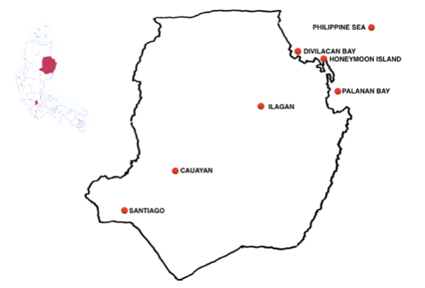
Looks like …. … a clown fish swimming upwards to the northeast
“WHAT’S ISABELA GOT?”
Isabela stands out because it is first and foremost very big (2nd out of 81), the largest Province on Luzon. It has a substantial population of 1.6 million (15th out of 81) but, thanks to its size, has a low density (67th out of 81).
It is a regularly shaped province – somewhere between a square and a rectangle – and consists of two distinct parts: the majority of it, on the western side, highly developed with main roads running north to south, the other one quarter largely uninhabited, indeed, even unexplored.
The western area is a fertile valley where the extensive plains and rolling terrain which have made the province the country’s top producer of corn (21%) and the second highest rice-growing province (15%), helping Isabela to be the 10th richest province in the Philippines.
The western section also has the only main roads running north to south and the Province’s three main cities: Ilagan (pop. ), on the Cagayan River in the centre NE? ; Caoayan (pop. ) to the x, site of the province’s only airport; and Santiago (pop. ) in the SW???
The eastern 1/4, dominated by the Sierra Madre mountains bordering the Philippines Sea, is completely different and far more challenging. These are high mountains – the highest point is Mount Dos Cuernos peak, (1,785 m / 5,856 ft) – with very steep slopes all rugged, thickly forested and largely uncharted. Designated the Northern Sierra Madre Natural Park this area is one of the finest remaining virgin forests in the country and home to a rich variety of flora and fauna, including Philippine eagles.
Two of the leading attractions in the province draw attention for their size. The first is the Magat Forest Reserve, in the southwestern corner of the province, 30 minutes from Santiago. The Reserve is home to the mammoth Magat Dam Tourism Complex, Southeast Asia’s biggest dam, consisting of a huge hydro-electric power plant and the large lake formed by the dam, a pleasant location for picnicking and various water sports, including fishing.
Isabela’s second gargantuan attraction, situated in Ilagan City, is the world’s biggest butaka, the local word for a wooden armchair. It stands nearly 4 m / 12 ft high, over 6 m / 20 ft long, and almost 3 m / 10 ft wide and is recognised by the Guinness Book of Records as the largest in the world. It was built in Ilagan to promote the city’s reputation for excellent furniture made of quality narra wood.
Tops among Isabela’s numerous old churches is the Baroque-style San Matias Parish Church, southeast of Ilagan. Made entirely of ornately designed red bricks, it has been officially designated a National Cultural Treasure.
The province’s natural attractions are in the mountains to the east, many of them not far from Ilagan city. In the foothills of the Sierra Madre Mountain Range, 15 kms / 10 m north of Ilagan, the Fuyot Springs National Park comprises a huge wildlife sanctuary, botanical gardens and the Santa Victoria Caves – more than 12 limestone caves with beautiful sparkling rock formations and subterranean waterfalls.
In San Mariano, south of Ilagan, the Dicatian Mangrove Forest is a vast and eerily beautiful place with Dunoy Lake, where there is a Sanctuary for a wild population of Philippine crocodiles.
One of Isabela’s most unusual annual events is the Mammangui Festival, celebrating “binallay” ,a popular Ilagan rice cake.
“WHERE ARE THE BEACHES?”
OVERVIEW:
Isabela has some 120 km / 75 m of coastline with at seven white sand Top Beaches split between two very large bays called Divilacan and Panlanan.
DETAILS
Isabela’s beaches are only a short distance from the capital, Ilagan, but still almost entirely undeveloped because they are separated from it by the dense Sierra Madre mountains, with no roads between the two. Access to these beaches is via 30 minute flights in six seater planes from the airports in either Tuguegarao, to the north of Ilagan, in Cagayan Province or Caoayan, south of Iligan.
Flights for the three beaches in the large northern bay, Divilacan, land at a small airport in the town of Maconacon in the southern corner of the bay, followed by a 30 minute trike ride south. Two of the virgin beaches here – Kabikawan and Bilagbag are in the same large cove, separated by only a small point.
The third beach on Divilacan Bay, Oway, is in a much smaller cove
on the southern side of a much larger point, called Dicatian,.
Travellers to Panlanan, the second of the Province’s two big bays, fly into tiny Panlanan town, which is located just south of the rugged, eagle shaped landmass between the two bays.
Despite having an airport, things are very quiet in Palanan (pop. 18,000), its streets empty most of the time except for some tricycles and a few horses. But it has three white sand beaches – said to rival the world-famous beaches on Boracay – all on the right hand side of the Bay. The first is Demolit, halfway along the bay at Culasi town.
Then comes Debenbenan Beach, which is on the far side of a large river and best reached by boat from Culasi. Finally, beyond Debenbenan, there is Dicotcotan on a point on the right hand side of Palanan Bay, also best reached by boat from Culasi
….. Dicotcotan is a three-kilometer long white sand beach with coral reefs, fringed with a coastal forest and a village…. such a paradise … – “Dicotcotan” means “to sink”…. the sand is so soft that one’s feet sink, leaving a deep trail of footsteps. … tranquillity, nice ambiance, uncrowded , just friendly locals, …. feels like you’re the only tourist … you own the place!!! … love this place so much, … if you want to escape from your life for a bit … … enjoy for low cost the food for the wealthy: a fresh catch of Blue Marlin, Prawns and Blue Dot Lapulapu.
These two bays, Divilacan Bay and Panlanan Bay, are only a short distance apart but it is impossible to pass from one to the other on land. The best way to link them would be with a visit to Estagno Island – sometimes referred to as Honeymoon Island – just off the northern tip of the eagle-shaped point that separates the two bays
…. one of the most beautiful beaches I have seen in the Philippines … no doubt it belongs to the top beaches in the country … its crystal clear waters have coral reefs teaming with fish … next time I want to spend overnight just watching the stars . …
MANILA’S SEASIDE ESCAPES – ROUTE 9:
THE PROVINCE OF AURORA
From Manila: Bus 230 km / 150 m (6 hrs) northeast
to Baler, capital of Aurora.
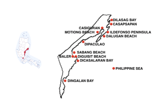
Looks like …. … a long, narrow head yawning
“WHAT’S AURORA GOT?”
Aurora is a reasonably large province (42nd out of 81) but it is an extraordinarily thin, some 300 km / 190 m north to south but only 40 km at its widest, the north and south ends, and as little as 10 km / 7 m wide at its narrowest, in the middle.
It also has a relatively small population of only 200,000 people (70th out of 81) which means it had extremely low density (77th out of 81).
The reason for this low density is simple: the province is almost totally mountainous with forest covering 70% of it – to the west and the entire southern end. Indeed, the entire southern portion of the Province is filled with the huge, mountainous and largely uninhabited Aurora Memorial National Park.
Baler, the province’s capital (pop. 40,000) and the rest of Aurora can be reached from Manila via two routes, one around the northern edge of the park , the other slower, more scenic route, which includes 50 km / 30 m through the Park.
Certainly director Francis Ford Coppola felt Baler was accessible when he chose it as the setting for “Apocalypse Now”, his remarkable 1979 Vietnam war film featuring a US Army platoon using Baler Bay for surfing while jets dropped napalm on the villagers all around them. Baler town is often said to be the birthplace of surfing in the Philippines, with waves that can reach up to 3 m / 10 feet high.
The main action in Aurora takes place on its coastal flatlands, the 30% of its land that is not forest served by the Province’s main road.
Aurora was first explored by the Spanish in 1571 and a Franciscan mission was founded in Baler in 1609. The Province is named after the wife of the second President of the Philippines, Manuel L. Quezon, who was born in Baler.
Aurora’s economy is predictably agricultural with copra and rice the principal products. Weaving is an important cottage industry, centred on the weaving of hats made from “brutal”, a fine white fiber from the leaves of “talipot” palm trees.
Baler has a beautiful Catholic church where a garrison of 50 Spanish soldiers held out against Filipino insurgents for a whole year, surrendering only in the summer of 1899, the last pocket of resistance of the Spanish Armed Forces.
Baler sits on a vast plain at the south end of Baler Bay, in the midst of remarkable rock formations, backed by the Sierra Madre mountain range, which includes the Aurora Memorial National Park. This is an eco-tourism Park with rainforests rich with a diverse range of flora, fauna and birds (vultures, falcons, hawks and the endangered Philippine eagle) making it a popular area for trekking and mountain climbing.
Another popular visitor destination is Ermita Hill, where Baler’s residents took refuge when the were swamped by a tsunami destroyed the town in 1735. Today Ermita Hill is used by hikers and campers who enjoy the views over Baler Bay.
Aurora’s most spectacular waterfall among many in the Province is Ditumabo Mother Falls west of Baler.
The “Millennium Tree” in the town of Maria Aurora, inland from Baler, is a 600 year old balete tree more than five stories high, the largest in Asia.
“WHERE ARE THE BEACHES?”
OVERVIEW
Aurora’s 14 Top Beaches are found along its 330 km / 200 m coastline, which is marked by four very different features: a jagged landscape in the northern quarter containing three distinct bays; the much smoother second quarter on the very wide Baler Bay; a straight quarter facing the Philippines Sea; and a final quarter around a point, heading south.
DETAILS
The first top Beach in the north, 145 km / 90 m (3.5 hrs) from Baler, is Dilasag, one of the best beaches on north-facing Dilasag Bay. Parts of this big bay are easily accessible from the highway that passes nearby on the western – mainland – side of the bay but others, on the narrow eastern arm of the bay that juts northwards into the sea, are more remote and harder to reach.
…. the Dilasag Coast is a true getaway …. a coast with km upon km of white sand beaches alternating occasionally with forests, hills, and cliffs …. undeveloped features and natural attractions … offers the sensation of discovering something new and unspoiled ….
Only 15 kms / 10 m to the south of Dilasag is another small, north facing bay, Casapsapan, which has three distinct beaches.
Two of the beaches are on the west side of the bay: Diniog Beach, in a south facing cove at the top of the bay and, just to south of Diniog, but still quite near the top of the bay, Canawer Beach:
… pristine and clean water, long stretch of fine white sand, and coconut trees on the side. an ideal place away from the busy city life … the place is still undeveloped … no resorts here yet …
The third beach,Casapsapan, is further south, at the bottom of the bay, 3 hours north of Baler.
… the place is magnificent! …. a hidden paradise, which is often deserted … a pristine white sand beach …. excellent for swimming. … accommodation is available at hillside resort in bucolic Casiguran town, about 5 km to the south …
Backing onto Casapsapan Bay is the third and by far the biggest of the three bays, Casiguran, officially defined as a Sound. South-facing, it is very long and very narrow: some 30 kms / 20 m deep but less than 1 km / 1 m wide at its midpoint. The Bay’s eastern shore is formed by the equally long and narrow, arrow-shaped San Ildefonso Peninsula, which protects the bay from the monsoon winds that blow on and off from October through February. The Casiguran Sound has fine white beaches and many foreigners have made vacation homes along the coast to take advantage of the relative placidity.
Casiguran town at the very bottom, northern end of the Sound – close by Casiguran Airport, on the west shore – is the gateway to some wonderful off the beaten track and unspoiled beaches with various shades of powdery sand
The Sound has several Top Beaches along its accessible western side, like Calabgan and Motiong, both at its narrow mid-point.
….. endless serenity and solitude …. creamy brown sand, crystal clear waters and coral gardens plus well preserved mangrove forests.
But Casiguran Town is also the gateway to the incredible 2 km / 1.5 m long Dalugan Beach on Dalugan Bay on the far, eastern side of the spindly San Ildefonso Peninsula
.… takes some getting to: … there is a river you need a 4×4 to cross even at low tide … during high tide you must leave your vehicle and ride the ‘balsa’ raft …. a paradise! …. … feels like you have an island to yourself … remote and pristine, this wide stretch of white sand is totally deserted … walking form the tree line to the beach is a surreal experience, making you feel you are the very first person on earth to set foot on this enigmatic place. …. mystic beauty and awesomeness …. bring camping gear! …
The long Baler Bay coast starts immediately south of Casiguran Sound. First at the far north end of the Bay, only an hour’s drive from Baler Town, at the very mouth of the Casiguran Sound, is Dinadiawan Beach.
….. a Boracay-like place … the beach sand is not as fine as Boracay’s but it is white …
Dinasdiawan is immediately followed by the town of Dipaculao (pop. (24,000) which has some 20 resorts around Dipaculao Beach
… one of my fave beaches! … I could retire here! …. nice pearly white sand.
There are dozens of other good beaches heading south along the 85 km / 50 m length of Baler Bay from Dipaculao Beach, although many are best known for their outstanding rock formations rather than their swimming options.
Then, at the south end of the wide Baler Bay, there is Baler town itself and, fronting the town, Sabang Beach, the main destination in the whole of Aurora.
… the sand on this long beach is smooth and fine almost like that of Boracay except for the colour … famous for the beginning of surf culture in the Philippines, this is a cool local surf scene great for beginners learning to surf … sometimes there is no swell … too few good waves so surfing … during low tide where you can walk in the beach or in the shallow waters, with the calming waves brushing against your legs. …. a great way to distress! …..
The second Top Beach at Baler is Cemento, 40 minutes away on foot or just 10 minutes away via a motorised bangka from the mouth of the river at the south end of Sabang Beach,.
… known for its chill atmosphere, this secluded beach is made of white sand and crushed corals . a popular destination for surfers. waves tower up to 14 feet high, From October to February, … great for snorkeling during the calm season from April to June.
Further on beyond Cemento, on the tip of the final point on Baler Bay, is Diguisit, a picturesque beach with pebbly coral sand & unique boulders, looking out to Ayao Island.
Continuing around the final point south of Baler and further south the final, more regular coastline of Aurora, is marked by two Bays, accessed in less than an hour by boat from Baler. The first is Dicasalarin, a vast bay which has various coves, caves and beaches, as well as a Grotto of the Blessed Virgin and a rich coral reef.
South of Discasalarin, near the very end of the Province, is Dibut, a much smaller baywith more beaches, imposing cliffs and a rock formation named “Birhen” (meaning “Virgin”), because it resembles the Virgin Mary praying amidst the waves.
TOP RESORTS
El Oceano Resort, San Ildefonso Peninsula, Casiguran
…. beautiful resort … very tranquil place … surrounded by mountains packed with coconut trees and beach waves that always call you to swim … rooms are very clean … top notch staff that will assist you with everything … the best accommodation on this side of the planet …
Punta Sierra Verde Resort, Dinalungan
….. home away from home … relaxing view of the beach and the mountains … friendly staff… great food … choice to swim from the beach or take a dip in the pool …
Sand and Stars, Dinadiawan
… beach is really nice … cottages and tents are all very comfy and cozy in design … staff are very nice and accommodating …. main highlights are the sand and the stars …perfect for stargazers … perfect for glamping experience … I’ll definitely go back here for more …
La Sunshine Resort, Dipaculao
… newly built …. such a beautiful and clean place to unwind … a very accommodating reception … wonderful calm ambiance …
Porto Novo Hotel, Dipaculao
… a hidden gem … nice location by the beach … … among the best places to stay in the area .… clean and affordable rooms. … provides a good view of Dinadiawan white beach .…very quiet and you can stargaze at night … I loved the isolation … the white sand beach is very wide and long with all the resorts spaced far apart …
Costa Alexa Beach Resort, Dipaculao
…. so serene … perfect if you want to take it slow and be relaxed … great place spend time by yourself or with someone special or to bond with the family … wonderful chance to sit back and simply enjoy nature . . .
Easy Adventure Resort, Baler
… very relaxing place and the natural surroundings and views are just wonderful …
Costa Pacifica, Baler
… probably the best hotel in Baler … truly amazing … exactly beachfront … four star accommodations that’s often fully booked 6 months ahead … excellent rooms with very comfortable beds and balconies …clean modern washrooms … staff are all very gracious and polite ….
Aura Marina Sands Beach Resort, Baler
… a small boutique resort with a bohemian feel … the rooms are in converted shipping containers and yet more than comfortable … very nice infinity pool with tremendous views of ocean and mountains … the staff were kind, courteous …
MANILA’S SEASIDE ESCAPES – ROUTE 10A
THE PROVINCE OF QUEZON – THE MAINLAND
From Manila: Route 1: Bus Southeast 160 km / 100 m (3.5 hr) to Lucena,
the capital of Quezon

Looks like … …. a coat hangar on its side in the sea, facing northeast.
“WHAT’S QUEZON GOT?”
Quezon is a huge province (7th out of 81) so that despite its large population of 2 million people (12th out of 81) – a third of them in the capital city of Lucena (700,000) – it has a relatively low density (45th out of 81), meaning that it has lots of wide open spaces.
Quezon is a strong contender to win the title for “Luzon’s Strangest Shaped Province” – a mass of angles, twists and turns – long and narrow with a huge bite taken out of its middle, between two long thin portions,
It is unique in that it opens onto at least 3 different seas, the top portion is sandwiched between the Sierra Madre mountains and the Philippine Sea while the southern part is largely a Peninsula with water on both sides – to the west the Tayabas Sea and to the east the Ragay Gulf.
Due to its fragmented shape, it has an immense coastline, some 1,000 kms / 600 m with at least half a dozen significant bays, as well as a range of islands.
This long coastline means that Quezon is one Luzon Province where no one has any trouble remembering that they live an island. The majority of towns have easy access to the sea and fishing is inevitably a large part of the province’s economy. Away from the sea, the province consists of rugged terrain with patches of plains and valleys, one quarter of it forest covered.
The majority of Quezon’s attractions are easily accessible from its capital Lucena (pop. 700,000), starting with the 2,200 m / 7,000 ft high Mount Banahaw, near the western edge of the province .
Mount Banahaw was one of the most sacred sites for Tagalog people long before the arrival of the Spanish and has always exuded spiritual mysticism Today it is a pilgrimage destination for Filipinos, with many cults and religious organizations actually resident on the mountain.
Although considered an active volcano, it is also popular today with hikers, offering a choice of two popular trails – Tatlong Tangke and Cristalino – taking an average of 5 and 9 hours respectively to the summit’s viewpoints.
Quezon is home to many outstanding buildings built in the 1930’s Art Deco and Art Nouveau fashion. Many of the best are on the coast south of Mount Banahaw, in the town of Sariaya (pop 150,000). They include the opulent Enriquez-Gala Mansion, Gala-Rodriguez House and Villa Sariaya, all three built by coconut landlords who profited when the Philippines ranked as the world’s fourth supplier of the coconut oil, which was in demand at the beginning of the First World War thanks to its high glycerin content which was essential for explosives.
A first hand experience of Philippine country life is offered to visitors at the Villa Escudero, a resort on a coconut plantation that was founded in the 1880s, a few miles west of Mount Banahaw. Villa Escudero offers visitors one of the largest private antiquity collections in the Philippines plus tranquil nature watching and recreational activities – from fishing to rafting and swimming. Its popular Labasin Waterfalls Restaurant serves a traditional Filipino buffet lunch, kamayan style, while diners soak their feet in the shallow running water flowing into the Bulakin River.
Interesting earlier structures include the Casa de Comunidad de Tayabas, a typical “Bahay na Bato” constructed during the Spanish era, east of Mount Banahaw.
The Province is also noted for having more than 20 stone arch bridges made during the Spanish colonial era. Malagonlong, the longest and one of the oldest, is on the east side of Tayabas (pop. 100,000).
“WHERE ARE THE BEACHES?”
OVERVIEW
Quezon’s 44 Top Beaches are divided into two clear areas: one, the beaches on the mainland, to the west and southeast of the capital Lucena; and, secondly beaches on the Province’s islands to the east and southeast.
DETAILS – QUEZON’S MAINLAND BEACHES
Beaches on the huge Tayabas Bay that forms the southern edge of Quezon start with Guisguis at the extreme western edge of the Province around the town of Sariaya and run in a virtually unbroken string x kms all the way to Lucena. But it is further east, x kms due east of the capital, (pop. 25,000) on Pagbilao Bay that things really get interesting.
Here, off the town of Padre Burgos, there are two notable islands: Pagbilao Grande (about 7 km / 4 m long) and hanging, just south off the right side of Grande, the smaller Pagbilao Chica (maybe 3 km / 2 m long).
Pagbilao Grandehas two of Quezon’s Top Beaches:
Puting Buhangin
…. an impressive stretch of sandy shore at the extreme southern tip …. lined with coconut trees to provide you with that much needed shade …. swimming here is ideal because of its white sand and clear blue waters. ….
Kwebang Lampas (aka Lukang Beach) is located on the same cove as Puting Buhangin, just a short walk beyond the rocks at the right end of the beach.
… wow! … its really a beautiful place .…the beach, white sand and the clean water is really really amazing … so excited to come back. … I’m in love with the place..… the crystal clear water, white sand and the incredible view of the island … very suitable for swimming because of its wide shore, fine white sand and clear blue waters … has palm trees lined up along the shore if you want a break from the sun … we enjoy the creamy sands and clear waters. ….best in the area for swimming ….
Pagbilao Chica Island’s Top Beach is called Borawan:
…. is a very small but picturesque place with a white sand beach … With pristine white sand beaches, gorgeous tropical backdrops, it’s like going to Boracay or Palawan but without the added travel costs … the white sands of Boracay and the limestone cliffs of Palawan.(Bora/cay and Pala/wan – get it?) … amazing place to go solo because it’s quite and safe even for an overnight camping … clear waters, serene and simply beautiful! … has 3 stations, the best Station 3 is near top on the east side facing the mainland
Dampalitan Beach is on a piece of land hanging off the mainland 10 minutes southeast of Borawan:
… an isolated beach facing south towards Tayabas Bay …. lined with pine trees …. similar to Anawangin and Nagsasa Coves of Zambales … there are tables for rent and camping is allowed. … its sand is finer than Borawan’s …. not great for swimming but there is abundant shade which makes it highly suitable for camping .…
The area also has two remarkable sandbars: Balugbog Baboy, created where the waves from Pagbilao Bay meet the waves from Tayabas Bay, and Tulay Buhangin (“Sand Bridge”), a 400 m / 1,000 ft long cream sandbar at the northern end of Calilayan Island (aka Patayan Island), an apostrophe-shaped island standing alone in the middle of Pagbilao Bay.
Padre Burgos is situated at the top left hand, western side of the Bondoc Peninsula, which extends southwards from the Quezon mainland and offers at least half a dozen Top Beaches. Two of the best are situated near Catanauan town (pop. 70,000), half way down the Peninsula, some 90 km / 55 m (2 hr) south of Padre Burgos.
The first, just north of Catanauan, is Gatasan:
…. Gatasan stretches about 2 km / 1.5 m along the Peninsula, with sand that ranges in colour from light great to delicious cream ….
The second, around a small point south of Gatasan, is on Catanauan Cove
…. the cove has a very nice beach but the highlight was the boat trip to two islands, to Maniwaya and then to Mompong, which has a very beautiful white beach on its northwest tip and a unique land bridge rock formation on its eastern fringe, good for cliff diving …. laid back island ambiance … Super amazing Island! …
Further south, at Mulanany town, Long Beach is popular for its lovely mocha brown sand and then, near the bottom of the Peninsula, 10 kms / 6 m north of San Francisco town, there is Kulong-Kulong Beach.
Off the southeastern tip of the Bondoc Peninsula, just a 20 minute bangka ride from the small town of San Andres, is the lovely, simple island of Alibijaban,
….. unspoilt and serene …. white sand beaches and clear waters …. still undiscovered and undeveloped ….
Heading north from San Andres, halfway up the eastern side of the Peninsula, the first stop is San Narciso, facing the Ragay Gulf, the nearest town to Talisay Beach.
…. a simple little paradise minutes from San Narciso! …. amazing! …looking for a white beach? Talisay is on … beautiful sunset view.
Just a little further north of San Narciso, halfway up the Peninsula, Buenavista town offers several promising beaches, including Cawa, Cabong and Mabutag.
TOP RESORTS – MAINLAND
Villa Del Prado,
…. … love this place …. has such a wonderful atmosphere.… beach is clean and pools are spacious enough both for kids and adults …
Pueblo Por La Playa near Padre Burgos
… like an entire Mexican village transplanted to Quezon. … a quiet secluded resort “town” for people who enjoys a bit of space… water views from some of the cottages … a couple of wonderful huge infinity pools close to the beach …. .… food is great as well …
Punta Tierra Blanca Beach Resort, Gatasan Beach
… very nice place … good food and friendly staff … the beach is awesome … we enjoyed swimming in the crystal clear light blue water … was like swimming in an infinity pool in the middle of the sea … a few hundred meters out in front of the resort the sand bar at low tide was beautiful … great place for a family holiday …
Catanauan Cove Resort
… an extremely beautiful place … a relaxed resort with 12 tropical, beachfront hectares and two infinity pools along Catanauan Bay… Well kept grounds with good access to beach … cottages by the beach … quiet and good for families. … …
MANILA’S SEASIDE ESCAPES – ROUTE 10B
THE PROVINCE OF QUEZON – THE ISLANDS
From Manila: Bus East 100 kms/60 m (3.5 hrs) to the port town of Real
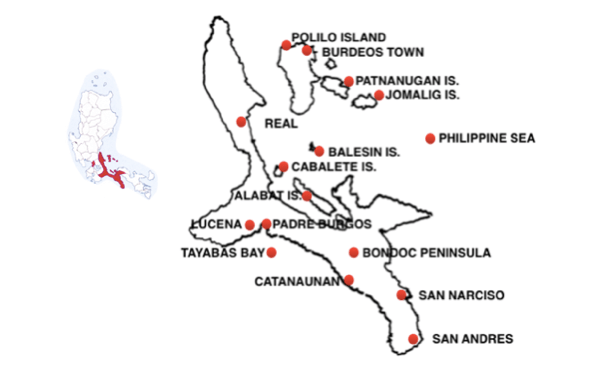
Looks like … … a coat hangar on its side in the sea, facing northeast
QUEZON’S ISLAND BEACHES
There are 5 distinct destinations:
- The Polillo Group of 27 Islands
- Jomalig Island- perhaps the best beach in the world
- Balesin Island – the tiny millionaire’s paradise
- Cagbalate Island –
- Alabat Island –
*****
POLILO GROUP OF ISLANDS –
From Manila: Bus east 100 kms/60 m) (3 1/2 hrs)
to the port town of Real, then a boat 30 kms / 20 m ( 3 hours)
Just 130 kms / 80 m due east of Manila – barely 6 hours from the capital and yet largely untouched – lie 27 of the country’s most remarkable islands and islets. Formally known as the Polillio Group of Islands, they are now becoming known simply as PoGI.
Boats for PoGI leave from Real, which itself can be worth a visit for its scenic views offered along its zigzag roads through the Sierra Madre Mountains, attractions like the Balabag Falls and beaches known for surfing, It even has its own island haunt, pine tree clad Baluti, just 3 km / 2 m offshore.
The logical first port of call for visitors to PoGI is the small town of Polillo, set deep in Polio Harbour at the southern end of the largest of the 27 islands, a long island running north to south Polillo (pop 70,000).
From Real substantial Lantsa passenger boats or sea crafts Mercrafts (no RoRos) leave at 7 am and 10 am for the 3 hour trip across the Polio Straits to Polillo Island, to Polio town on the southern end or to Anawan Pier slightly to the north.
Say something about Polilo???
An enormous concrete arch of the town’s endangered species called the Polillo Tarictic Hornbill greets visitors as they enter the town proper towards its plaza complex. The town also has a baywalk with a small park for children.
Polillio Island has a rugged interior, with mountain ridges running through its center. Their peaks routinely rise to 100 and 200 m above sea level, with the highest peak, Mt Malulod, soaring to 350 meters. Most of the island is untouched, making it an epitome of what pristine really means.
Burdeos in the northeast corner of the island offers opportunities for mountain climbing (Mt Malulod) and Short Spelunking (Puting Bato Cave)
The island is home is home to several animal and tree species that are unique to the island, including the very large (180 cm / x in) Gray’s monitor Lizard weighing – 9 kg / 20 lb -, a important relative of the Komodo dragon.
“WHERE ARE THE BEACHES?”
Polillo is remarkable for the variety of its beaches, where the sand ranges in colour from white to black … to pink. There are at least three Top Beaches within an hour of Pollilio town (pop.??) :
The closest is Bato Beach, situated just off the circumferential coast road to the south of the town.
…. picturesque golden sand and crystal waters … boasts pink sand and beautiful crystal clear water … beyond my expectations.
Some5 km / 3 m (30 m) north of Polilo there is Bucao Beach, lies
..… the clear water and white sand here reminds me of the Maldives ….
Anawan Beach is further on but still only an hour to the north of Polilo.
….. perfect for snorkeling because of its coral reefs rich with school of fish like galunggong, bolinao and green sea turtles.
But the PGoI is best know for the exciting beaches on the 25 smaller islands and islets that lie off northeast coast of Polilo, off the town of Burdeos (pop 25,000), which can be reached by boat (3 hours) or by road (5 hours) from Polilo:
…. a rough muddy ride similar to many off beaten paths, it is a no place for a faint-hearted but a thrilling adventure in order to experience the rustic simplicity and untouched beauty of nature at the end …
From Burdeos, there are at least 10 highly prized island hopping options including:
Binumbunan (aka Bumbunan) is only a 10 minute boat ride from the Burdeos port of San Rafael, with a thriving fishing scene.
…. a circular island that looks like a burger bun from afar … so small you can walk all around it in 15 minutes. … the most preferred camping site because
Anilon (1.5 hrs off shore)
… a long coastline of golden beach sand and crystal clear waters …. this was our favourite camping spot and perfect for star gazing ….
Anawan
….. can be considered as the “Boracay of Burdeos” with its enticing crystal clear bluegreen seawater and Boracay-like coastal shores.
Minasawa
….. a peaceful retreat. Around 30-40 minutes from Pulong Kukok, you can find this luscious island rich with biodiversity. …. as well as a white sand beach it has a forest sanctuary for sea birds …. Perfect for snorkeling.
Kabalo Sandbar (aka Katawian/Calagoa Sandbar)is just 20 mins away from Minasawa:
…… has a fine white sand anchored by two small limestone rock formations this small but terrific sandbar I long coast of powdery, white and very fine grains of sand surrounded by sparkling crystal clear blue-green seawater.
Kokoc Sandbar is30 minutes away from Minasawa:
….. has a fine white sand with two small limestone rock formations that make it a great place for picture taking ….
But these are only the top destinations. Many other islands can be visited including Malaguinoan, Biguitay, Ikulong, Palasan, Kabalwa, Calutcot, Bakaw-Bakaw, Puting Bato and, lastly, Pulong Buhangin, a small but beautiful sandbar
TOP RESORTS
Isla Polillo Beach Resort, Bucao Beach (5 kms / 3 m north from town)
… the cottages are built with bamboo, coconut tree, mangrove trees and the surrounding exotic gardens parallel the beauty of the natural setting ..… the serenity of this beach resort is amazing, with its lush surroundings and the melodic calls of the many birds that frequent the area …
Puting Bato Beach Camp, Burdeos
… this camp is detached from everything and the nature around you is overwhelming … a place not for glamping but legit camping …
*****
JOMALIG ISLAND
From Manila: Bus east 100 kms/60 m) (3 1/2 hrs) to the port town of Real,
then a boat 6 hrs.
“WHAT’S JOMALIG GOT?”
Getting to Jomalig is invariably an adventurer’s treat. These boats are not regular passenger boats but cargo vessels that carry fish from Jomalig but also accept passengers. The trip can be especially difficult from September to January due to huge waves.
Oblong Jomalig island itself is the third largest – and at the far eastern edge – of the PGoI but still quite small, only 55 sq. km/ 20 sq. m (roughly x by x) and home to only 7,000 people.
“WHERE ARE THE BEACHES?”
Jomalig’s premier beach is Salibungot;
…. a long stretch of golden sand uniquely dotted with agoho trees and a sandbar on the other end during low tide. at the western tip, convenient for sunsets …. no crowd, no development … very Robinson Crusoe! …
But Jomalig is surrounded with golden sand and rich turquoise water providing half a dozen other appealing beaches including:
Canaway Beach at its eastern tip
…… there are weird rock formations scattered through out the beach …
Little Batanes
….. a patch of coast reminiscent of the Batanes islands at the very top of the Philippines ….
Golden Sandbar
….. a stunning glistening sandbar ….
Little Boracay
… a patch of Boracay-like white sand …
Meanwhile, there is a host of other fine beaches east of Jomalig, like the Pulo and Manlanat Islets, which can be reached on foot during low tide.
TOP RESORTS
South Pacific Island Resort, Salibungot
… facing the spectacular Salibungot Beach and sandbar! … kudos to the owner and staff for being so welcoming …
Pamana White Beach Resort @ Little Boracay
… a little piece of heaven on earth … so serene … I really like the colour of the beach …
Jojomalig Resort
Bananas Resort
Apple Beach Resort
******
BALESIN ISLAND
From Manila: Bus 180 kms / 120 m (4 hrs) to Atimonan town
then a boat 4 hrs
Alternative: – plane 60 m from Manila (20 mins)
“WHAT’S BALESIN GOT?”
Given its facilities are designed for the affluent, many of Balesin’s guests – mostly celebrities and multimillionaires. – avail themselves of the chance to go by air (approximately 25 minutes flight time from Manila to Balesin Airport)
Balesin is a very small island (500 hectare) and remote – on the very southern fringe of the 27 PGOI – but it is one of the Philippines most celebrated destinations, a privately owned island with the prestigious Balesin Island Private Member’s Club in the centre, with membership fees reportedly in the range 2-4 million pesos.
It is the antithesis of the other Polillio islands which appeal most to backpackers and adventure seekers,
Situated in the open sea, Balesin’s weather is clearly dominated by two seasons.
The Amihan (November / December and ends sometime in May / June) brings moderate temperatures and little rainfall. Throughout rest of the year, June to November, Balesin Island experiences the Habagat season, characterized by hot and humid weather and frequent heavy rainfall
“WHERE ARE THE BEACHES?”
There are pristine white sand beaches all around the island’s 7 km / 5 m long coastline.
TOP RESORTS
Balesin offers half a dozen world class resorts with names that give a taste of their global aspirations: Bali Village, Phuket Village, Costa Del Sol Village Mykonos Village, St Tropez Village and Toscana Village.
*****
CAGBALATE ISLAND
From Manila: Bus 5 hours south (x km/xm) south to the port town of Mauban
then a 50 passenger boat for the one hour.
“WHAT’S CAGBALLETE GOT?”
Cagbalete is a small (1,640 hectare) cone-shaped island with a rich variety of birds, including egrets, terns, hummingbirds, marine life for snorkelling and plants, including bonsai and Agoho pine trees, all surrounded with cream sand that stretches far out into the sea creating massive sandbars during low tide. When you can walk the 1 km to bonsai island.
It is extremely simple and undeveloped, favouring backpackers with a handful of small basic resorts on the south-eastern side of the island. There is no running water and no electricity in the island but some generators operate from 6PM to 6AM.
Food is in limited supply at some places with the best being packed lunches from resorts and so on. Villa Cleofas can prepare meals for guests or they can you or you can the kitchen themselves.
“WHERE ARE THE BEACHES?”
Pansacola on the southeastern side EXPAND!
…… beach front is the best in the island …
TOP RESORTS
Villa Cleofas,
… the beach is very shallow which is perfect for kids … the sandbar is awesome … during high tide, everyone can sit on the sandbar and enjoy the waves coming in …
Villa Noe
….. really peaceful and quiet ….
Pansacola Beach Resort,
… we tried various huts and our favourite was the treehouse … best part – NO NOISY KARAOKEs day or night !!! … fantastic! … we loved the sand bar and the long walks along the beach ….
*****
ALABAT ISLAND
From Manila: Bus 180 kms / 120 m (4 hrs) south to the port town of Atimonan
then boat one hour to Alabat Port.
“WHAT’S ALABAT GOT?
Alabat Island, lying between the Pacific Ocean and the calmer Lamon Bay, has excellent fishing grounds, fertility of the soil, wide plains and An unusual fusion of semi commercial towns and a virgin hinterland with a single road down the eastern coast and hiking trails through the mountains.
Alabat Island (pop. 40,000) is a reasonable size (192 sq kms / 74 sq mi) composed of 3 towns: Alabat, Quezon & Perez with wharfs serviced by ferries & chartered bancas from the mainland.
Alabat port town (pop. 16,000), on the east side Alabat Island, has a .nice gate with hummingbird or something leading into a next clean town … Seems like a very sweet, quiet, clean place.… for heritage homes, then this is your Disneyland in sepia. blocks after blocks of beautiful old houses that scream of 1900s nostalgia. As the town is small, most people here either walk or ride a bike to move around. There are only a few motorized vehicles which are only used for utilitarian purpose. a community living on less air & noise pollutions.
A vast marine sanctuary for fish & giant clams fringes Alabat Island.
Visitors can go aboard a bamboo raft in the middle of Lamon Bay to snorkel, then chill out over hearty lunch then cruise along its lush mangrove forest on the way back
“WHERE ARE THE BEACHES?”
Alabat town is so spic and span that Alabat Beach, near the port, offers excellent swimming.
There is a more tropical experience to be had at Villa Norte Beach by the quaint fishing village of Villa Norte which is due east on the island’s Pacific Coast, at the end of an adventurous 20 minute tricycle ride along a snaking mountain road that offers excellent views of the island.
…. a cream sand beach with crystal clear waters and, facing the Pacific quite a good swell during the summer and impressive waves during monsoon season.
TOP RESORTS
Nil. …
MANILA’S SEASIDE ESCAPES – ROUTE 11
THE PROVINCE OF CARAMARINES NORTE
From Manila: Bus 350 km / 220 mi southeast (10 hrs) southeast to Daet,
capital of Caramines Norte
Alternative : Fly to Daet (45 mins)
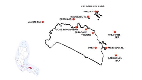
Looks like …. …. a sleeping cat tilted to the southeast,
its tail drooping to the northwest
.
“WHAT’S CAMARINES NORTE GOT ???”
Caramines Norte is a relatively small Province (55th out of 81) with an equally small population of 600,000 (51st out of 81) but still a high density (36th out of 81)
Its capital is the fast developing town of Daet (120,000) which is aggressively vying for city hood by embarking on several large-scale projects, including a facelift of the town plaza, a P30-million government center, a P30-million transport terminal and an improved airport.
Its leading agricultural product is a pineapple nicknamed the “Queen of All Pineapples” due to its sweetness and flavour, and the province holds a colourful 10 day Pineapple Festival every June to celebrate this crop.
On the nature side, the province’s highest elevation, Mount Labo (1,600 m / 5000 ft), has clear rivers, creeks and a number of refreshing waterfalls, – Saltahan, Burok Busok Palanas – that make it appealing to hikers.
One of the province’s best waterfalls is also one of the most accessible, the multi-tiered Malatap with a a natural swimming pool in the town of Labo, only short hike from Malatap Bridge on the main road.
“WHERE ARE THE BEACHES?”
OVERVIEW:
There are several easily accessible beaches on the mainline near Daet town but, more importantly, there are 18 Top Beaches on three nearby island groups.
DETAILS:
The Top Beach near Daet, just 3 kms to the east, is Bagasbas:
….. a wide 2 km / 1.5 m long stretch of fine grey sand with a promenade that spans the best part of it making for easy access … a great spot to chill … its waters are good for both leisurely swimmers and surfing beginners. … … … During low tide, you can see the flat sand formation making it safe for kids to play .… … Very clean, wide and long beach and clear waters. ….. big waves … a great place for surfers … Near good hotels, and a local restaurant … scenic views at nightime …
Just north of Bagasbas is a second popular beach called Mantigbi.
The first of the many islands easily accessible from Daet lie just a few minutes southeast, off the small fishing town of Mercedes, at the mouth of San Miguel Bay. These are the Siete Pecados, seven islands – Apuao Grande, Apuao Pequeña, Caringo, Canton, Canimog, Quinapaguian and Malasugui – grouped close together but each with unique features:
Apuao Grande
… lovely fine white sand beaches backed by shady agoho trees … lots of pine trees act as cover for the hot summer days… the place is deserted and untouched … crystal clear waters, gorgeous landscape, and the sunsets are stunning ..…. has beach cottages with amenities for family picnics, beach bonfire parties and overnight camping … offers day tours to any of the half dozen nearby islands
Apuao Pequena
… 15 to 20-minute hike through a Bat Sanctuary with huge bats flying overhead in the trees right on the beach … there’s a stunning view point shrouded with a grove of trees overlooking the rocky coast known as “Surfer’s Paradise.”
Quinapaguian
…close to shore, below Apuao . … has an outstanding beach ….
Further afield but still easily accessible from Daet are various beaches and islands to the north and west. The first beaches are reached via Jose Panganiban town (pop. 2,000), which sits at the bottom of a deep cove – at the beginning of the Province’s “cat’s tail”.
Pag-asa Beach
….. on the west coast of the cove is just 3 kms / 2 m north from Jose Panganiban… clean, white sand beach .… popular for swimming and water sports or camping overnight … already has cottages and comfort rooms … safe place when you need to have an alone moment even at night.
Parola (aka Tailon) Island
… 40 mins by boat due north of Jose Panganiban town …. virgin and unspoiled .. a small privately owned island with beaches on both the main sides … Parola Beach aka Pink Beach is known for its pinkish-coloured sand which is clearly visible when the sun starts to set. … the pink sands is produced when the local red coral gets awashed ashore …. when the tide is out you can walk several hundred meters offshore …There are no no inhabitants and no facilities on the island No stores, no electricity, no resorts.
There are at least three other islands nearby with fine beaches: Tabusao (also due north of JP), Calalanay and Padoni
…. less crowded yet these islands are at least as beautiful, maybe even more beautiful, than Parola …
Moving east from Jose Panganiban, there are many beaches on Caramines Norte’s far east coast, around the small fishing port of Paracale, located at the bottom of Paracale Bay. Three of the best beaches are just north of the town.
Bulalacao Beach
…. in a cove on Pulang-Daga Bay facing Maculabo island …. an unspoiled white sand beach …. a new discovery for most people …. not many houses or people .… visitors have the beach mostly to yourselves, … great location for campers and night photographers chasing the milky way!
Just south of Bulalacao is Gumaus Beach, and in a different bay further south, but still north of Paracale, is Pulang-Daga Beach (aka Pulang Lupa):
…. this stretch of white sand (actually semi-white and brown, especially during summer) makes it ideal for a day tour and family getaways … ideal for swimmers and offers a great panoramic view of the ocean … a good spot to capture the sunset.
Paracale town itself has an excellent beach just to the north of the town center,Buhangin,and only slightly south of Paracale, liesLabnig, a final excellent local beach.
The top island off Paracale is Macolabo Island
… a gem … situated opposite Bulalacao Beach … only an hour’s boat ride from Paracale .… known for its fine white sands and turquoise blue waters … not crowded …. perfect for people who’d like to remove themselves temporarily from the hustle of city life.
But most of the Manila beach lovers who make the journey to Daet go on to the port at nearby Vinzons for a 2 hour boat ride east to the pristine Calaguas Group of Islands, which includes three major islands: Tinaga, Guintinua, Maculabo and several smaller ones. The centrepiece is Tinaga island, the largest of the group and the best known, for its fabulous beach Mahabang Buhangin
…. this island has the wow factor. … its pristine three-kilometer stretch with powdery white sand and clear blue water. below the green hills … It is like paradise. …… the beaches at Boracay and Subic, Bataan, Batangas and Quezon pale in comparison …. Calaguas beach has the cleanest shore, the finest sand, the clearest water! … with absolutely beautiful blue sea and soft, fine sand. … popular camping ground but there are now plenty of cottages and resort in … the surrounding rolling terrain and hiking trails present a more active alternative to lying on the beach … construction is tastefully done, blending into the trees. The beach was lovely and clean. it was not overcrowded. … local government is promoting eco-tourism to protect the beauty .
There is a second Top Beach in the Calaguas group on Balagbag island just minutes to the north of Tinaga.
…..it was a joy just to look at the beach … the fine white sand gently massages your feet when you walk … located between green hills, it makes a pretty picture indeed.
….. was like being in Batanes!!! … highly recommend the trip, so worth it! ….
TOP RESORTS
Bagasbas Lighthouse Hotel Resort (4.1) Bagasbas Beach
…. This is the best hotel on Bagasbas …. next to the beach … the rooms are a good size with good air conditioning … an older place and they have made some upgrades and are still working on others … has a nice pool and a playground for the kids … the restaurant is good and there are two better ones a short walk away … has a bar with music and outdoor seating so it is pleasant in the evening.
Pineapple Island Resort (3.9) in the town of Calasagan, Daet????
… has a huge 720- square meter swimming pool with water slides for adults and a 200- square meter kiddie pool with a turtle slide and play station for kids. … also has a greenhouse, butterfly garden, bamboo huts, various fishing and boating lagoons, and villas for rent for those who want to stay overnight.
MANILA’S SEASIDE ESCAPES – ROUTE 12
THE PROVINCE OF CARAMARINES SUR
From Manila: Bus 400 km / 250 m (9 hrs)
to Naga City, capital of Caramines Sur
Alternative route : Fly to Naga,
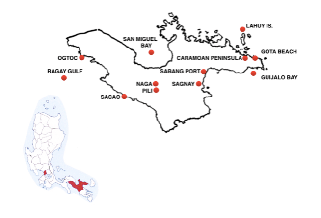
Looks like … …. an inverted anvil, its base to the northeast
“WHAT’S CAMARINES SUR GOT ???”
Caramines Sur is fairly large Province (16th out of 81) and weirdly shaped, with a large rectangular western portion giving way to a smaller eastern lump in the ocean. It has a fairly large population, 2 million people (13th out of 81), meaning it has a high density (19th out of 81). Nevertheless it has some of the country’s least explored areas, particularly to the east, thanks to the rugged terrain there which means the bulk of the inhabitants reside on the western side.
At the center of the western portion, on the Bicol Plain, are the Province’s two most important cities, Naga (pop. 200,000), the province’s religious, cultural, commercial and industrial center; and, close by, Pili (pop. 100,000), the capital, with the Province’s main airport.
Both cities are surrounded by vast cornfields and rice fields with some forest. In addition to rice and corn, Camarines Sur’s agriculture-based economy encompasses coconut and sugar with the surprise addition of abacá, and, most surprising, water-lily. There are water lily farms all over Naga.
Caramines Sur’s major industries are food processing – mainly coconut and pineapple – and the manufacture of housewares, toys and jewellery.
One of the Province’s most unusual products is freshwater fish pulled from the Province’s three southern lakes: Buhi, Bato, and Baao. Buhi near the city of Iriga at the foot of Mt Iriga, in the south, is the home of sinarapan, the world’s smallest commercially harvested fish
The lakes aside, Caramines Sur’s defining geographical feature is Mount Isarog (2,000 m / 6,600 ft high) which stands to the east of Naga and guards the narrow entrance to the anvil, the mountainous Caramoan Peninsula. Mount Isarog is home to the critically endangered Isarog Agta language, spoken by the earliest settlers in Camarines Sur, the Isarog Agta people.
Naga is known as “The Pilgrim City” because its Our Lady of Peñafrancia church, completed in 1750, is the destination for the largest Marian pilgrimage in Asia. There are notable 19th churches in San Jose and Sagñay, both southwest of Naga.
The Province’s two potentially active volcanoes, Mount Isarog, near Naga, and Mount Asog (aka Mt Iraga) in the south, both have hiking trails that make it easy for visitors to explore their rich biodiversity and to enjoy the clean, cold rivers feeding various waterfalls. One river, close to Pili, with fully eight waterfalls.
The Province’s most singular attraction is the six-hectare Camsur Watersports complex in Pili, based around a lake where an cable suspended 10 m / 30 ft above the water provides wakeboarding & water-skiing at speeds up to 65 kmh / 40 mph.
“WHERE ARE THE BEACHES?”
OVERVIEW
Camarines Sur at least 18 Top Beaches. There are Top Beaches on the mainland along the route to Naga and just beyond the city but Province’s main attraction is the beaches further east on the Caramoan Peninsula and island hopping.
DETAILS
The road to Naga offers some tempting stops long before reaching the city, with various stunning beaches on the Province’s western coast facing the Ragay Gulf, including Bagotayok Beach near the top of the Bay; Ogtoc Beach, further south, on Saboon island; Poro Beach on Poro, one of the Tres Marias islands at the end ofa Peninsula; and finally, only a little further south still, some 30 km / 20 m (1 hr) west of Naga, Pasacao Beach, sometimes called “The Summer Capital of CamSur”.
….. I’m from Naga City, but Pasacao is still one of my favourite beaches in Cam Sur … nothing much has changed there over the years … it is still clean … so good and refreshing ….
On the other side of the Province, east of Naga, the road skirts around the southern slopes of towering Mt Isarog to a series of beaches on the Laganoy Gulf around the town of Sagñay (SW of Naga) including Patitinan White Beach
… amazing hidden beach! …. with a secret trail leading down to it … the beach and surroundings are stunning … not developed …
And there are several more popular locations, with a mixture of black and white sand beaches shielded by coral reefs, further east still, along the road at Sabang, (Partido) San Jose.
But most Manila beach lovers travelling to Caramines Sur press on past these first, easily accessible beaches to catch the boats from Sagnay and Sabang to the Province’s extreme eastern Caramoan Peninsula – the right hand tip of the anvil – and the islands just off shore,
….. the islands and beaches of Caramoan will rival any in the world … better than Boracay for sure and at least on a par with those in Palawan …
The Caramoan Peninsula is so rich in natural splendour that there are Top Beaches within a stone’s throw of Guijalo Port, at Caramoan Town on the southern edge of the Peninsula, which is the disembarkation point for boats coming from Sagnay and Sabang, outside Naga.
…. with crystal clear turquoise waters and white sandy coves located on both sides of the Guijalo pier, this is one of the better-looking ports in the country …
Still most visitors naturally travel further on to two great beaches on the northern edge of the rugged Peninsula, part of the Peninsula’s 70 km / 45 m of beautiful Pacific Ocean coast.
Paniman Beach
…..an island hopping starting point but also a destination in itself. …… a good place to picnic until sunset with drinks and snacks brought from the nearby town and there is a floating resto bar and a few restaurants where you can belt out some tunes.
And just south of it, still accessible by road all the way from Naga, Gota Beach
…. an attractive place to stay.
But the piece de resistance in Caramines Sur is the sand to be visited while island hopping on the boats running from Paniman and Gota. Local operators usually divide the mind boggling array on offer into a choice between short trips to some islands less than an hour away and longer trips to the islands further out.
The short route’s prime six stops are:
Matukad ….
…. boasts a gorgeous fine-sand beach, lush tropical forest backdrop, and hidden lagoon obscured by a tall limestone cliff … the lagoon is perfect for swimming, the waters are calm and clear …
Kagbalinad
…. what’s unique about tranquil Kagbalinad’s white sand shore is its relatively, crystal clear shallow water … you can actually view the seabed all the way up to the neighboring Hunongan Cove … its stunning rock formations offer a panoramic view of Gota Beach just a short distance away
Lahos
….. a wonderful tiny beach between 2 rock clusters, so tiny that it disappears during high tide . … the island has two major rock formations opposite each other, allowing a small beach to stretch between them, creating shorelines on either end of the island …. an untainted piece of paradise …. simply lay back and bask in its raw beauty.
Bagieng
… a small island but it has 2 long, sandy beaches.
Hunongan –
…. on the mainland to the right of Gota but around a small point and accessible only by boat … an isolated, highly rated cove on the fringe of the Caramoan National Park, with its own resort
The second package tour takes in at least several more distant islands, including of these five major stops :
Manlawi
…. has the biggest sandbar of Caramoan … imagine eating your lunch on a floating cottage, an ice-cold beer in your hand while dangling your feet in the inviting blue-green seawater …
Lahoy
… the biggest of the local islands … it has fully 10 km long stretches of fine sandy beaches
Cotivas
….. has a white sandbar that connects to the nearby island of Guinahoan, which can be visited by foot during low tide by wading at the deepest point … there are cute nipa huts on bamboo stilts …
Sabitang Laya
…. boasts two beaches of creamy white, fine sand extending up to two kms /1.2m …. the Survivor’s series favourite spot …
Tinago
….. “Tinago” means “hidden” and this island’s beach cove is indeed “hidden,” accessible only through a narrow passageway between two limestone rock formations …
TOP RESORTS
Tugawe Cove Resort, Extreme right hand tip of the Peninsula???
….. this is a piece of heaven … the staff are warm and friendly … offers gorgeous infinity pools, pristine white-sand beaches and underwater wonders together with breath-taking views of the sea and hills …
West Peninsula Villas, Where?
…. great place for family outing …
Hacienda Lahuy Island Resort, on the southernmost tip of Lahuy
…. nice cabins and white sand! … seldom visited and looks pristine .…
Hunongan Cove Resort, Hunongan Beach
…. only accessible by boat … a great getaway place, if you want a complete disconnect from the world and enjoy being lost midst pristine nature … perfect for a complete recharge! …
Gota Village Resort, Gota Beach
… great staff … great restaurant with very tasty food … you can eat inside or by the beach ….
MANILA’S SEASIDE ESCAPES – ROUTE 13
THE PROVINCE OF CATANDUANES
From Manila: Bus 500 kms / 300 m (11 hrs) to Legazpi City
Alternatively: Fly (1 hr) to Legaspi
From Legazpi: Van 30 minutes north to Tabaco City
then boats (4 hrs) to Virac, the capital of Catanduanes.
Alternatively: Fly Manila to Virac.
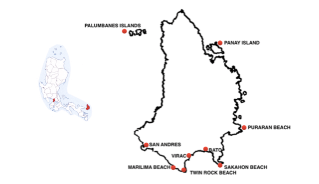
Looks like …
….. a small head with a hat on facing southeast.
“WHAT’S CATANDUANES GOT?”
Catanduanes is a substantial island, the 12th-largest in the Philippines, but still very small, only 90 km / 50 m (2 hrs) north to south and averaging about half that east to west.
So it is small in terms of the country’s provinces (70th out of 81) but has a similarly small population of 260,000 people (67th out of 81), giving it a relatively sparse density ranking (50th out of 81).
Wild, uninhabited landscapes predominate, although its highest peak, Mt Cagmasoso, is only 800 m / 2,600 ft high.
As with many islands, its main artery is a coastal circumferential road skirting the rugged interior, although in the case of Catanduanes this road is often far more ragged than curving, particularly on the east, Pacific coast.
The capital of Catanduanes, Virac, (pop. 2,000 ), lies the south coast, on the wide south facing Cabugao Bay.
Situated well out into the Pacific Ocean, the island is naturally exposed to incoming storms. In the past it was was often referred to as “The Typhoon Capital of the Philippines” but the winds have changed over recent years, lessening the problem. In any case, Catanduanes has many deep bays and coves, notably Virac’s south facing Cabugao Bay, that offered passing ships safe anchorage.
Because of its rugged terrain, the province abounds with waterfalls, like the Maribina Falls in Bato, just east of Virac, which is one of the most popular thanks to its shallow multi-layered basins.
There are various prehistoric caves on Catanduanes, including the Luyang Cave in San Andres, west of Virac, where scores of natives were choked to death in the 17th century by Moro pirates by burning red pepper. Luyang is now used for adventure races to a clearing on the far side of the mountain, en route to a trail to San Andres.
There are quaint stone chapels around Catanduanes as well as massive old churches. One of the most impressive old churches stands in Bato, close to the Batalay Holy Cross Shrine, site of the first cross on the island.
The province is home to various mollusk fossil sites, including the second oldest ammonite site in the Philippine (100 million years old) and sites with species that can’t be found anywhere else in Southeast Asia.
Its rich geologic history means the province has a high chance of being declared a UNESCO Geopark Reserve.
“WHERE ARE THE BEACHES?”
OVERVIEW
Catanduanes has 12 Top Beaches divided among three clear areas: to the west of Virac, on the southwestern coast; on the eastern Pacific coast; and on islands either side of the northern tip.
DETAILS
A line of fine beaches starts just 15 minutes to the west of Virac. Most of them face southwest, with many of them offering great sunsets and a view of the sublime Mt Mayon in Albay. The list starts with Twin Rock Beach (formerly Igang Beach) just around the point at the western end of Virac’s Cabugao bay, at the extreme southwestern tip of the island.
…. a semi-circular stretch of sand on an idyllic cove surrounded by green hills … overlooked by two rocky hills that the locals call “the twin rocks” …
To the northwest of Twin Rock, there are beaches facing the Lagonoy Gulf and Mt Mayon all the way up the coast to the town of San Andres, starting with Bosdak Beach, then Marilima Beach
…. a wonderful getaway all in the midst of nature …. The unspoilt beach’s gleaming white sands are bordered by the clear blue pristine azure waters sea stretching as far as the eye can see and by coconut trees against a hill … …. At low tide, the sand is laid bare for miles; you have to walk quite far out to swim. At high tide, however, the water completely cover the shore. … with a full view of the breathtaking Mayon Volcano .. …
North of Marilima is Batag Beach:
… a coral-strewn beach whose charm is enhanced by a rock arch ….
Then comes Mamangal Beach:
… … a sprawling shoreline of white sand lined with the cool, shady trees …shining blue crystalline waters with brilliant reefs swarming with a great number of colourful fish varieties.
Finally, close to San Andres is Amenia Beach:
…. the best place for sunset gazing with its calm waters and the perfect-coned Mayon Volcano on the horizon ….
To the east of Virac, on the promontory at the eastern end of Cabugao bay, is Batalay Beach, together with an extensive Mangrove Eco-Park and, at the extreme southeastern tip of Catanduanes, Sakahon Beach …..
…. such a good beach …soft sand and clean water ..… the rock formations are beautiful ….
But for many visitors, particularly surfers, the main attraction on Catanduanes is Puraran Beach, which is located only 40 minutes from Virac,at the town of Baras, 1/3 of the way up the eastern Pacific coast:
…. this unspoilt beach offers fine cream-colored sand and unusual seaside rock formations … a very laid back ambiance …. definitely a place to relax and enjoy life …. … one of the Philippines first recipients of grand Pacific waves … a great spot for surfing …
Still, for those seeking escape, the gem of Catanduances may well be off-shore, on the pretty Palumbanes Islands, an hour away by boat from Caramoran Town, near Pandan, at the north end of the island. The Palumbanes consist of three islands: Porongpong, the largest, has Bitaog Beach.
….. an extensive light warm beige, pinkish, with an open cottage and a hut for overnight … deserted with residents on the other side of the islands … and explore coral formations 20 meters away,
Porongpong is flanked by two smaller islands: Calabagio, to the right, has a rocky shoreline that makes it impossible to dock.
However, Tignob, to the left, is easily accessible and appealing:
…. it’s completely uninhabited …. you can take a dip or go snorkelling
in crystal-clear waters in utter peace ….
On the opposite side of Catanduances, a short boat ride takes visitors to the calm of Panay Island and Loran Beach, another unspoilt patch of fine sand.
TOP RESORTS
Twin Rock Beach Resort, Cabugao Bay
… my favourite resort in the island … a very relaxing place where you can enjoy the sea breeze …. family oriented with affordable food …. both the beach and pool are nice …its adventure facilities include a zipline and an outdoor climbing wall …
MANILA’S SEASIDE ESCAPES – ROUTE 14
THE PROVINCE OF ALBAY
From Manila: Bus 530 km / 340 m (12 h) to Legaspi City, capital of Albay
Alternative : Fly (50 mins) to Legaspi.
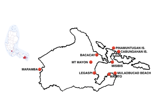
Looks like …
….. a small crouched rabbit facing east
“WHAT’S ALBAY GOT?”
Albay is a relatively small province (53rd out of 81), barely 50 km / 30 m east to west and north to south. Despite its small size it has a relatively large population of 1.4 m people (20th out of 81) which means it has a high density rating (12th out of 81).
It is essentially a rectangle, with ears, a nose and a tail – like a rabbit – with water on either side and several islands on its eastern edge.
It is generally mountainous with only a smattering of fertile plains. The eastern part is marked with a line of volcanic mountains running north to south: Mt Malinao followed by Mount Masaraga and the free-standing Mt Mayon, the highest point of the province (2,500 m / 8,000 ft) and then, on the southern side of Poliqui Bay, the Pocdol Mountains. The mountains to the west are less dramatic, with the highest elevation a mere 500 metres / 1,600 ft.
Despite these mountains, agriculture is Albay’s main industry, covering the usual Filipino crops – coconut, rice and sugar – and, notably, abacá, which is used to produce an array of products from hats, bags and slippers to furniture and home decor. Forestry, paper-making and cement are other major elements of the economy.
Albay is also renowned for Pili nuts, which are used in candies, with the best of the nuts harvested on the slopes of Mt Mayon.
Albay’s capital, Legazpi (pop. 200,000), at the southern foot of Mount Mayon on the shores of Poliqui Bay, has been ranked as one of the most liveable cities in the Philippines. Its centre has two important districts: Old Albay and Legazpi Port, on Poliqui Bay, which was used by the Spanish galleon ships carrying cargo to Mexico in the late 16th century.
The keynote to Legaspi is the perfectly symmetrical Mt Mayon stratovolcano, just to the north of the city, a magnificent, scenic backdrop, variously described as … awe-inspiring … stupendous …. sublime …..and stunning. The only downside to Mt Mayon is that it is the most active volcano in the Philippines, having erupted almost 50 times, often with devastating consequences.
The most destructive eruption, in 1814, destroyed vast parts of the area including the nearby Cagsawa Church, just a few minutes north-west of Legaspi. Its ruins are a top visitor site today.
The most popular intact church is the baroque Nuestra Senora de la Porteria constructed from volcanic rock in 1773 on a hill to the west of Legaspi, facing Mount Mayon.
Legaspi’s tourism industry puts the accent on adventure, offering zip-lining, skydiving and ATV rides over rough trails to the Mt Mayon’s lower slopes. Outside the city, the adventure activities include river rafting and spelunking.
Visitors looking for more sedate activities retreat to Albay Park in centre of Legaspi to see over 300 animals including the rare Philippine Hawk Eagle and crocodiles or to use the small boats on offer for fishing on the Park’s lagoon.
The Province’s natural splendours start with some excellent stalactite and stalagmite formations in the Hoyop-Hoyopan Cave on a quiet hillside above a pretty valley 25 km / 15 m west of Legazpi.
To the east of Legaspi, in the town of Manito on the far side of Poloqui Bay, there is a huge ‘boiling lake’ called Nag-Aso, fed by a hot spring with temperatures up to 100° Celsius, which is hot enough to boil eggs.
“WHERE ARE THE BEACHES?”
OVERVIEW
Albay has half a dozen Top Beaches divided between its two coasts – including that rarest of seaside oddities, black sand beaches – and on the islands to the east.
DETAILS
Albay’s black sand beaches are the result of Mt Mayon’s various eruptions, the hot lava spewed out having cooled and then been eroded to fine particles over millions of years. The best of these black beaches face the Lagonoy Gulf an hour north of Legaspi on Mayon’s eastern slopes, near the town of Bacacay ….
….. the contrast between the black sand, the blue water and the green trees make a unique sight! …. charming ….
There are white sand beaches on both Albay’s east and west coasts: the extensive Muladbucad White Beach isdue east of Legaspi, on the opposite side of Poliqui Bay, near the town of Manito, while Sabando Ocampo is a renowned beach stop on the western coast at Maramba, Oas.
But Albay’s best Top Beaches lie to the northeast of Legaspi on the Province’s islands opposite Mt Mayon Volcano, most notably on Cagraray, the largest of the four main islands, and on two of its satellites.
For many the all star Top Beach in Albay is one of the closest to Legaspi, a pristine 1 km stretch of golden sand along the southeastern tip of Cagraray at Misibis. It can be reached from Legaspi either in an hour along the island’s scenic southern road or in only 30 minutes by a fast watercraft yet remains delightfully isolated.
…. a private beach, ensuring calm …
Further from Legaspi and justly admired for their more remote situations are two of Cagraray’s satellite islands, one small, one large, with excellent beaches.
East of Cagraray’s northern tip is large Cabungahan Island and Cabungahan White Beach:
……. superb for nature lovers who want to go to an isolated island … no electricity … experience nature and the beach at its finest ….
North from the tip of Cagraray on tiny Pinamuntugan Island is Pinamuntugan Beach, reached by an hour’s bangka ride from Bacacay’s Tabaco Port, north of Legazpi.
…. this white sand beach is as beautiful as the best beaches in the Caramoan Islands … clear water, perfect spot for hideaways … a treasure haven … a must visit place …. nice, calm Beach with really white sand, on the coast nice coco palms, on the end of the beach with rock formations … stay in a tent overnight …. true nature! .… Robinson feeling ….
TOP RESORTS
Viento de Mar Beach Resort
…. Nice clean resort. Clean grass and kobos. Small but nice black sand beach. …… This place is beautiful; the huts look amazing, friendly dogs and horses running around on the property ….
Costa Monte Private Villa, southern edge of black beaches
….a hideout in the outback for a quick day away from the world …. luxurious home with a pool, sprawling property and a cool breeze from the ocean .. just bring plenty of food as this is in the outback …
Muladbucad White Beach Resort, Manito
…. awesome rooms with a breathtaking view of Albay Gulf …
Misibis Bay Resort (4.3) Misibis
…. luxury 5-hectare playground …. a tropical hideaway built on a pristine stretch of private beach … exclusive and privileged … a beautiful place … 37 Asian-inspired villas with high, airy ceilings, expansive terraces and direct access to the pool or a secret path to the beach … excellent service … staff were all smiles …
MANILA’S SEASIDE ESCAPES – ROUTE 15
THE PROVINCE OF
SORSORGON
From Manila: Bus 580 kms / 361 mi (11 hrs) southeast to Sorsogon City,
capital of Sorsogon
Alternatively: Fly (1 hr) to Sorsogon
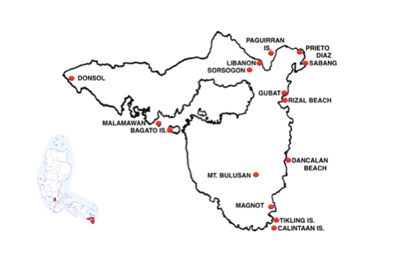
Looks like ….
….. a wolf’s head with a deep, angry mouth facing west, its ears jutting out to the northeast.
“WHAT’S SORSOGON GOT?”
Sorsogon is one of the Philippines’ smaller provinces (59th out of 81) but has a significant population of 800,000 people (35th out of 81) so it is quite density populated (35th out of 81).
It is the most southernly point in Luzon. Going any further south means crossing the San Bernardino Strait to the island of Samar.
Mountains dominate both its eastern and western portions, meaning that its half dozen major towns – and the majority of its population – lie along the coast – linked by major roads either side of Sorsogon Bay – and down its two southern coasts. Its tallest peak, Mount Bulusan, (1,560 m / 5,120 ft) lies in the southwest in the southern town of Irosin- near the centre of the wolf’s jaw.
Sorsogon’s capital, Sorsogon City (170,000), is set deep in Sorsogon Bay, facing west, with the Philippines Sea to the east.
One of the Province’s most important products is abacá, (or Manila hemp) made from fibre from banana trees and processed to make a wide range of products, from banknotes to teabags.
Given its small size, all of Sorsogon’s attractions are easy to reach, with many of them very close to the capital or along the shores of Sorsogon Bay.
The Buhatan River Eco Adventure Cruise, from Bhuatan, west of Sorsogon, uses a floating cottage to offer a seafood dinner feast on a 5 km / 3 m stretch of river, to the Sorsogon Bay area, with thousands of fireflies lighting the way.
Bulusan, one of the country’s most active volcanoes, offers a variety of activities, from swimming in hot and cold springs in a forest at the base of the mountain and kayaking on a lake to doing the 40 minute trek up the mountain, a walk highlighted with a hanging bridge above the treetops.
Sorsogon’s notable historical buildings include the 150 year old St Joseph’s Church set in a huge courtyard in Barcelona, on the coast south of Gubat, with majestic stone walls and a well preserved bell tower, both made of coral rocks.
There is a 114 year old lighthouse reaching over 40 m / 135 ft on the high rocky headland of Bagatao Island in the entrance to Sorsogon Bay.
Top of the list of Sorsogon’s attractions has to be the chance to mingle with the whale sharks off the fishing village of Donsol on Sorsogon’s west coast. These animals are huge – averaging 10 m / 33 ft in length, with mouths up to 1.5 m / 5 ft wide – and were believed dangerous until 1997 when an adventurous group of scuba divers proved they were harmless.
A standout among Sorsogon’s annual events is the Pili Festival, based in Sorsogon and honoring the highly valued nuts from the Pili tree, which is indigenous to the Province, with street dancing by locals in Pili nut costumes, nut-cracking session and fireworks.
“WHERE ARE THE BEACHES?”
OVERVIEW
Sorsogon is surrounded by water on three sides giving it lots of coastline as well as half a dozen / 4 important islands with at least 14 Top Beaches, almost all of them less than an hour from Sorsogon City
DETAILS
Sorsogon City has at least a dozen Top Beaches only minutes to the east.
Closest is Swanga Bacon, directly to the east on Albay Bay facing the Pacific, while a short distance due north of the city is the extraordinary Libanon Beach,
…. has its own special charm, particularly its enigmatic black sands … its fine ebony sand is complemented by mysterious black rock formations …
But the best of Sorsogon’s Top Beaches are found a little further away, just off the coast road on the wide Peninsula running northeast of Sorsogon.
….. this Peninsula is shrouded in secrets … beautifully different … a castaway ambience … life here is unhurried … so many pretty things to see. …. its coast is rugged, meandering and riddled with tropical beaches blissfully uncharted by mass tourism ….
The first stop up the west coast of the Peninsula, an hour east from Sorsogon, is Paguirran Island, in Albay Bay facing the Pacific:
….. aside from the island’s pinkish white sand, it has a picture-perfect lagoon located a few meters away from the beach that visitors can walk to or, when the tide is high, take a boat … … so beautiful! … the lagoon is awesome … the clear water is so great to swim in … the beach is also quite nice ….. so much natural beauty … a group of islets including one with a lagoon inside..
North from Paguirran Island, at the tip of the Peninsula, there are various notable beaches, such as San Roman and Tutin followed by the best of the lot, Lebanon:
…. sensuously soft white to cream sands and azure water make perfect for lazing around .… you can dive the astonishing coral reef formation inhabited by rainbow-hued fishes and other marine animals.
Starting south from Lebanon the road follows the east coast down to the pretty town of Prieto Diaz, only 20 km / 13 m (45 mins) from Sorgogon, and the highly rated Sabang Beach.
…. great place …. super clean and beautiful … on its way to developing
its facilities …
Sabang is also the jump off point for the paddle bangkas handling the 45 minute ride through a marvellous mangrove forest to the spectacular Halabang Lapis Sandbar:
…. a sparkling white sandbar stretches to about 800 m / 2,500 ft shaped like a long pencil. … with a view of Albay’s large Rapu-Rapu island
Continuing south on the road from the Peninsula, 20 km / 15 m (30 mins) to Gubat (pop. 60,000)) there is another Top Beach, Rizal, to the southeast of Sorsogon but still close by, facing the Pacific
…… a long stretch of beach … clear white sand and cream coloured sand…. nice sea views … amazing sunrise and sunset views … lots of cottages and picnic tables as well as overnight accommodation for travellers and for corporate events …
Carrying on south from Gubat there are at least two more Top Beaches on the mainland. First, a further 25 km / 15 m (40 mins) south the road runs to Dancalan Beach north of Bulusan town, about one hour south of Sorsogon
….. a good beach to take a dip … crystal clear water, sparkling white and light brown sand ….. . simple yet lovely and elegant…. …. a picnic perfect beach under the shade of swaying coconut trees … cottages on its shore mean it is now possible to stay overnight …
After Dancalan, the road turns right and inland meaning that the beaches south of beyond Bulusan – south of Bulusan Volcano – are reached by a single small road. The only town of note on the route is Sta Magdalena, close to Magnot town at the southern tip of Sorsogon. Here the Top Beach is Olango:
…… very nice … a serene place … nice seashore with fine sands, with flat surface rock formation on the shallow shore …. no big waves so even children can play on the shallow water ….. I so love this beach! … the beach has fine, white, powdery sands … a laid back place …very relaxing …. relax while basking in cobalt clear waters and soft tropical breeze … check out the colorful underwater habitat …. during habagat, the breeze blows strong and steady creating waves perfect for surfing …
In addition to all these mainland beaches, Sorsogon has at least 4 islands that are also notable for having Top Beaches. Two of the islands are at the mouth of Sorsogon Bay. Malawmawan is a very small island on the north side of the mouth of Sorsogon Bay. It is one hour away from the port at Macalaya on the north shore of Sorsogon Bay, 40 km / 25 m (1 hr) from Sorsogon.
…. a shore made up of cream sands and crushed corals between soothing coconut trees and blue waters. …. a tadpole-shaped stretch of pristine beach with ochre sands and turquoise waters. … Malawmawan is a private island and it has a brown-sand beach and a long stretch of sand bar. …. small, in just three hours, you can walk around its entirety ….. wild ducks and other … no resort but one small hut where you can stay for the night and allows overnight tent camping but there’s no electricity … no stores so bring enough supply.
South of Malawawan Island, still in the mouth of Sorsogon Bay, is much bigger Bagatao Island, which is close to the south shore and reached in a few minutes from Magallanes which is 60 km / 35 m (1.5 hr) from Sosogon. Visitors come here forParola Beachat Bagatao’s northwest tip:
…. the beach is directly below the island age old parola (lighthouse) which stands on the headland … unexploited … simply breathtaking … the corals are wonderful and multi-hued fish dwell near the beach ….
But the best of Sorsogon’s beaches, lie on two islandsoff the Province’s southern coast, a short hop from the quaint fishing village of Matnog (pop. 40,000) on the San Bernadino Strait. Matnog is the absolute end of the road from Manila, but only some 40 km/ 25 miles (50 mins) from Sorsogon.
Best known of the two islands is Calintaan, 40 minutes away by boat from Matnog. It is a small and undeveloped place, with just two typical Filipino fishing villages, Calintaan and Calayuan, which are completely free of traffic.
The star attraction here is Subic Beach on Calintaan’s south coast which is actually divided into two segments. The locals call this pair appropriately Subic Laki (Big Beach) and Subic Liit (Small Beach). ,
… visitors can reach the beaches directly by boat or on foot from the villages …. the village children love to be tourist guides. … The island is small enough to easily circle by boat to discover interesting caves and small beaches … take a boat to check out the fish farm on the neighbouring island of Juag …. the water is always crystal clear and of best quality. … …. epitomizes the beauty of tropical island cliché. … unique pearly pink shores … lush mountains plummet into the coral-fringed turquoise water that is ideal for snorkeling. … coastline of the beach has stunningly rich corals …. no posh resorts or luxury trappings …. camping is the best way to enjoy its unblemished beauty …. pinkish power dry white sands
But Subic Beach is being challenged by Tikling island which is even smaller and closer to Matnog, only 20 minutes away by boat.
…… the white talcum-powder coast, clad by palm trees swaying in the gentle breeze, is long enough for a leisurely walk beside a seductive thread of emerald and cerulean waters ….. approaching Tikling, I remember thinking, “Wow, another unspoiled white beach” but the moment I set foot on the island, I saw that the beach appeared more pinkish because of the powdered red corals scattered all throughout the sand …. Tikling Island is peaceful and beautiful offers unending serenity for you … the only inhabitants thrive on simple fishing and copra production ….
TOP RESORTS
Suki Beach Resort, San Rafael, Santa Magdalena
…. great place to relax! … beautiful, quiet place with great people and delicious food …. very cosy … five stars for the beach and swimming pool …
Sunset Beach House, Subic Beach, Calintaan Island
…… this two room beach house is located right on the coast with stunning views of the mainland, the sea and Masbate island … Fantastic sunsets … the view of the sun setting and the tides rippling up to the room is an idyllic experience. …. island hopping was a highlight of our stay …
MANILA’S SEASIDE ESCAPES – ROUTE 16
THE PROVINCE OF BATANGAS
From Manila: Route One: Bus southwest 60 km / 40 m (1.5 hrs)
to Mt Palay Palay National Park
Route Two: Bus south 100 kms / 60 m (2 hrs)
to Batangas city
Route Three: Bus southeast 150 km /100 m so (4 hrs)
to San Juan town.

Looks like …
… a bat flying northeast, with a lake at its heart
“WHAT’S BATANGAS GOT?”
Batangas is a medium size Province (44th out of 81) but it scores high on the population side with nearly 3 million people (7th out of 81), reflecting its proximity to Manila. This gives it a high density rating(6th out of 81), with numerous new large cities throughout the Province, like Tanauan (pop. 180,000); Santa Thomas (pop. 180,000) and Lipa (pop. 300,000) and, Batangas (350,000), capital of the Province.
The Province is a prime example of an area in transition from agriculture to urban living and Batangas city is one of the fastest urbanizing cities of the Philippines.
The city still has rural landscapes in the northern fringes and there are patches of agriculture – coconut, corn, vegetables, and mangoes – which remain an important source of food and income for residents of rural barangays. But most of the city has shifted to an industrial economy, drawing in migrants from the countryside and even nearby provinces.
There are an ever increasing number of business establishments – malls, banks, businesses and restaurants – in the city’s Central Business District, one of the largest oil refineries in the country on the lowland areas surrounding Batangas Bay, plus three natural gas power plants and several major industries in various industrial parks.
Batanagas has the second largest international seaport in the Philippines, after Metro Manila, and one of the country’s busiest passenger and container terminals, with links to many parts of the country.
Batangas’s growing population and increasing urbanisation has naturally heightened the appeal of its remaining rural areas, historical buildings and festivals.
Batangas is home to the country’s well-known Taal Volcano and the Taal Heritage town, which has ancestral houses and structures dating back to the 19th century. The Province’s historic buildings include fine basilicas and Old Spanish houses in the towns of Taal, Mabini, Lipa City and Batangas City.
Batangas City hosts many special events every year, including two major religious festivals: the Feast of the Santo Niño, every January, and the Sublian Festival, every July, reviving the old Batangueño tradition of subli, a dance in honour of the Holy Cross; The annual Batangas City Founding Day celebrations are done alongside the Sublian Festival.
One of the more unusual events every year is the Parada ng Lechon (roasted pig parade) held annually in Balayan on Balayan Bay.
Batangas is a relatively flat province – its highest elevation is Mount Makiling 1,100 m / 3,600 ft high – but it is still very appealing for hikers. One of the most popular hiking routes is the Mt. Gulugod Baboy Trail. It passes three peaks, the highest only 525 m 1,722 ft above sea level but still offering great views of Maricaban Island and Verde Island to the south, Batangas Bay and the city of Batangas to the west, and the Tagaytay highlands to the north.
One of many important Batangas foods is nilupak, a sweet and sticky native snack made from cassava and coconut, which is so distinctive that it may soon be included on UNESCO’s Intangible Cultural Heritage List.
“WHERE ARE THE BEACHES?”
OVERVIEW
Batangas has an extensive coastline with 22 Top Beaches spread across three distinct areas: on the 60 km / 40 m long stretch facing the South China Sea on the west; along two deep bays to the west of Batangas City; and to the east of Batangas City along the south shoreline all the way to Tayabas Bay.
DETAILS – ROUTE ONE – THE WEST COAST
From Manila : 60 km / 40 mi (2 hr) along the southern edge of Manila Bay through Mt. Palay Palay National Park to Patungan Cove
The Top Beaches on Batangas’s western coast facing the South China Sea begin at the Province’s mountainous northwestern corner and run 60 kms / 40 m (3 hrs) south to Punta Santiago at the tip of the beautiful Calatagan Peninsula. This is a long route that breaks naturally into two halves, the first 30 km / 20 m going south to the city of Nasugbu (pop. 120,000) on Nasugbu Bay and then on for another 30km / 20 m down to the Calatagan Peninsula.
The first half of the route’s Top Beaches begins with a remarkably ragged coastline, a landscape as dramatic as anywhere in the world, consisting of three distinctive promontories separated by two deep coves, each promontory with its own array of smaller coves.
The first promontory – the biggest of the three – starts at Patungan Cove, which has a fishing village at one end and a popular clean beach at the other. The promontory juts west away from the highway and immediately offers an extraordinary series of pristine white sand, mountain shrouded coves with names as exotic as their settings – Neela, Limbones, Dorada, Arkaya, Bilagao, Etayo, Subli, and Santelmo – which can only be reached by boat from Patungan Cove or from the final cove on the southern side of the promontory, Pico de Loro (Cutad) Cove, which has a 1.5km / 1 m long fine white sand beach.
After this first large Promontory comes Papaya Cove, the first of two big covers, which has beaches and resorts on its south shore,
The second, smaller promontory, south of Papaya Cove, has only one major cove, called Cayraang, but it is a stunner accessible by boat in less than an hour from Papaya Cove or from resorts to the south.
….. a hidden gem … a deep and calm retreat … protected by forested shores ….
Just south of Cayraang is Bituin Cove (aka Angara Cove):
….. a short strip of sand with very clean water … calm because it is protected by a manmade breakwater …. a rising camping destination …. …….
On the southern side ofthis second Promontory is the second of the two large coves, Calayo and a fishing village, also called Calayo,
… the Boracay of Nasugbu! … the beach has fine light brown sand with blue-green waters … slowly transforming into a beach destination … lined with several budget to mid-range resorts …
Calayo Cove is the jump off point for a 20 minute boat ride to another Top Beach on Pulo-Pulo Island, (aka Loren Island).
…… a fantastic island escape. …. has two beaches and a sandbar that links them to a small rocky islet. …. the island’s small cove part is welcoming with a beige sand beach and clear, clean water good for swimming ….. there are trees that serve as shade from the sun. ….. just beautiful ….
After Calayo Cove comes the third and smallest of the three northern promontories, the rocky, flame-shaped Punta Fuego Peninsula which juts 3 km / 2 m out into the South China Sea and is surrounded by half a dozen prettily named coves and beaches: Crescent, Coral, Long and Lost Beaches on the north side; Pirate’s Cove and Sailor’s Cove Beaches on the south side; and Sunset Beach and Fuego Beach at the far western end
South of Punta Fuego Peninsula is the beginning of long Nasugbu Bay which starts with another series of large coves with excellent beaches: Natipuan Cove, then Kawayan Cove and, finally, Canyon Cove, just north of Nasugbu town proper.
….. Canyon Cove is perfect for toddlers …. flat sea and warm water … the beach is really peaceful especially at night … good place to lie out and gaze at the stars ….
Nasugbu town, the halfway point on the coast,has its own huge beaches with numerous resorts but is best known for Fortune Island lying 1 hour to the west. Tiny Fortune was once a retreat for the wealthy, complete vacation houses fronting the beach, a swimming pool and a helipad. The island’s most prominent feature now is some abandoned Greek columns resembling a part of the Athens Acropolis.
… this place is a must-see ….a beautiful, mysterious island …. best to do an overnight stay there. … best campsite ever!… shore is wide and far so you’d really get to enjoy the water.…. the ruins are attractive and the water is so clear and abundant with underwater life … he sand is one of a kind …
South of Nasugbu, a small, sharp point marks the end of the huge Nasugbu Bay and the second half of this coast begins, the road soon passing by several of Luzon’s earliest big beaches, starting with Matabungkay:
… the very long shore is strewn with ashen sand that sparkles a white glow when hugged by sunlight …. there is a coral reef in the center of the cove which diverts the incoming waves beautifully. …
Beyond Matabungkay the road passes by another early discovery, Balibago Beach and, some 20 km / 13 m south of Nasugbu, arrives at Calatagan town (Pop. 10,000), at the beginning of the beautiful 10 km / 6 m (20 mins) long Calatagan Peninsula which has a series of white sand beaches and good resorts leading all the way to Santiago Point at the southern end of the West Coast.
First, sticking out below Calatagan’s big bay, is another of Batangas’s first popular beaches, Burot, but a little further on two newer destinations stand out as Top Beaches, starting with three beaches around the popular Stilts Beach Resort: Harmony and Destiny, which are part of the same stretch of sand, and Serenity which is separated from the first two by a low headland.
…. one of the best beaches I have ever been to … the white sand, the view is awesome …. the resort does not disturb the natural environment …
Just beyond these three, perhaps most interesting of all, is Manuel Uy Beach, one of the newest destinations in Batangas.
…… a really breathtaking beach … a long, wide strip of cream-colored sand lapped gently by Calatagan’s signature shallow waters … bookmarked by small rocks that jut out to the sea, adding some texture to the already picturesque cove … the sunset was beautiful … it’s child-friendly.……… you can wade through the little waves for ages and the water will barely reach your waist or chest .… a small inlet divides the long beach into two parts: one part to the north where the island hopping boats for Starfish island and a picturesque sandbar are stationed …. the other southern part is quieter …. no permanent structures along the beach but lots of treed areas where you can pitch a tent ….
ROUTE TWO: THE SOUTHWEST
From Manila: Bus southwards 100 kms / 60 m (2 hrs) to Batangas City
Between Calatagan on the West coast and Batangas City, all along the top of Balayan Bay, there is a wide choice of modest beaches and resorts leading to this area’s Top Beach, Sampaguita, on the far right hand side of the bay.
…. a long stretch of beach… exquisite! … the shore is squeaky clean …. bring goggles to see how beautiful the coral reefs are … isolated by surrounding tropical forest, t … perfect if you are looking for a quiet and peaceful getaway adventure …
Below Sampaguita is the lovely Mabini Peninsula, a 15 km / 10 m long finger of land jutting due south, dividing Balayan Bay from the much smaller Batangas Bay. The Peninsula boasts extraordinary marine life along its fringes and is regarded as the birthplace of scuba diving in the Philippines.
For beachcombers the Mabini Peninsula matters because it points straight to tiny, whale shaped Maricaban Island – 8 kms x 5 kms (5 m x 3 m) – which has sloping mountains at either end with rugged hills and valleys in between and three Top Beaches. Maricaban’s main port is Tingloy town on its northern coast, just 4 km / 2.5 m away from the tip of the Mabini Peninsula, and its first Top Beach is Masasa, due south of Tingloy, on the island’s southern edge.
….. a long, off-white stretch of sand … not pearly white but makes up for that in the vibrance of waves … its crystal clear, shallow waters give off a beautiful turquoise shimmer that catches the eye from a distance … very simple yet beautiful … I love the sand and the colour of the water, especially the blue lagoon. … for peace this is a great place …. the trip was worth it to see its beauty … we had so much fun travelling by tricycle from Tingloy through luscious green mountains with breathtaking views of the beach from the top …simply amazing to see the blue waters, oh so clear, and all those fish and corals …
The two other Top beaches on Maricaban are just minutes to the west of Masasa, The first is Oscar’s, which is managed by a resort but welcomes day trippers, and just beyond Oscar’s, Sepoc Point, at the western tip of Maricaban – at the whale’s tail – with sepoc trees and good snorkelling.
Just above Sepoc, tiny Caban Island also has a number of white sand beaches.
ROUTE 3 – THE SOUTH COAST
From Manila: Bus southeastwards 150 km / 100 m (4 hrs) to San Juan town (pop. 5,000), then 20 kms (45 mins) south to Laiya beach
It requires slightly more effort to reach Laiya than Batangas’s other Top Beaches to the west but its 5 km / 2 m long stretch of fine white sand is generally judged worth the trouble. Indeed, Laiya is regarded by many to be the jewel in the Batangas Crown:
… Laiya’s white sand beaches and clear waters are frequently compared to Boracay’s … plenty of lush trees and plants greatly outnumbering the resorts … very child-friendly because the shallow waters don’t suddenly go deep and the waves are gentle … beautiful off shore islands protect it from the big waves of the open sea ….
TOP RESORTS
Pico De Loro Beach and Country Club, Hamilo Coast
…. a 40-hectare “Residential Resort Village” … untapped paradise! …. peaceful and quiet … serene ….. very nice hotel and beach … surrounded by hills and forest … good swimming pool … good games rooms ….
Calayo Beach Resort, Calayo Cove
… very romantic …. traditional Bamboo “kubo” cottages … AWESOME! … a place to stay for a long break … they have a pool … the beach is less than 5min away. … good for kids as there is an island that blocks the big waves …
Club Punta Fuego, Punta Fuego
…. an 88-hectare residential resort with Spanish-Mediterranean styled casitas, most with a terrace or veranda facing the West Philippine Sea … spectacular sunsets …
private beaches, a golf course, marina and a heliport …. awesome place … beautiful setup with lots of nature – trees, flowers, birds – beaches and pools … the Casitas are spacious, especially the shower toilette. … fabulous …. love the double infinity pool. ….. beautiful, exclusive neighbourhood with fabulous homes of the extremely rich and wealthy. …..
Canyon Cove Hotel (3.9) just north of Nasugbu
…. looks nice in tropical grounds.
Coral Beach Club, Lian – far end of Matabungkay beach it seems
….. a beautiful view of the beach from our porch … the pool and hot tub were excellent …
Stilts Calatagan Beach Resort, just south of Burot Beach.
…. half a dozen overwater villas connected by wooden boardwalks over shallow waters nurturing an explosion of marine life … has one of the best beaches I’ve ever been to … great place for a weekend getaway or long vacation … the white sand and the view are awesome … friendly staff and exceptional service … food was delicious … hands down to a world class customer service! … our room was very spacious and nicely positioned in front of the beach with a nice shade from a tree at front … the pools were very clean …
Banak Hause, on Calatagan beach, south of Manual Uy
…. house looks and feels native but has facilities … a beautiful, quiet escape…. very peaceful and quiet ….
Sunrise Cove – West edge of Balayan Bay
… a one hectare property, with five bamboo cottages amid lush trees and greenery with a spacious private beach and bamboo raft floating offshore …
Residencia de Piego Beach Resort (x) Sampaguita Beach
…. lovely old native style bamboo cottages … a peaceful place with lush plants … … the bamboo trees everywhere give the place a tropical feel …. the swimming pool at night with the lights on is spectacular …
Destino Beach Club (4.8) Bauan (so also Sampaguita?)
…. beautiful resort … they have a chef and a pastry chef to prepare the great buffet meals … staff were very courteous and attentive ….
Punta Verde Resort (4.2) only halfway to Laiya
… a beautiful, elegant place … a tranquil resort surrounded by forest … rustic cottages on a secluded beach along the Verde Island Passage strait ….… amazing views and beautiful scenery …
Palm Beach Resort, western of Laiya Beach
…. one-stop R&R …. all rooms are well appointed with a view of the sea and direct access to the beach …. it has infinity pools and provides water sports. ….
La Luz Resort, Laiya Beach
… the cabanas beach side are plentiful … super helpful staff … a good place for chilling out with friends and family …
Virgin Beach Resort, Laiya Beach
…. very relaxing place … love the cabanas … wide beach front .. clean and tidy … at night, the beach is lit by capiz lanterns and bamboo torches which adds to the ambiance of the resort …. the beachfront is part of the Tayabas Bay which makes the sea calm ….
Acuatico Resort, Laiya Beach
….. the infinity pool was amazing. … leads out to the sea.…. resort has kayaking and paddle boat activities … definitely a great place for relaxing …. dinner is served by the beach with a fire dance …
Acuaverde Beach Resort, Laiya
…. Awesome place! … the facilities were clean with many bamboo details. …. excellent service! … courteous and friendly staff!
MANILA’S SEASIDE ESCAPES – ROUTE 17
THE PROVINCE OF CAVITE
From Manila: Bus 25 km / 15 m (30 mins) southwest to Kawit,
capital of Cavite

Looks like …
… a tea cup or flower pot tilted to the northwest.
“WHAT’S CAVITE GOT?”
Cavite is very small, the 4th smallest province in the Philippines (67th out of 81) and yet its population near 4 million makes it the most populous province in the country (1st out of 81), which means that it is also densely populated (2nd out of 81)
It is located along the southern shores of Manila Bay, starting just 20 km / 13 m (30 mins) south of Manila. Cavite is divided into three distinctive geographical areas: the coastal lowlands on the northern edge – the top of the flowerpot – on Manila bay; the central hilly area; and the upland mountainous areas around the southern edges to the east and west.
The Province’s most distinctive feature is a spur of land in its northeast corner – like a tiny, wilting flower – that juts into Manila Bay and points back towards Manila. This tongue of land creates its own harbour, Bacoor Bay, within Manila Bay, a feature which was immediately exploited by early explorers. The port was used by Chinese junks for trade and by 1565 it had became the main seaport of Manila hosting the bulky and lucrative Spanish galleons carrying Chinese luxury goods such as spices and porcelain from China to Acapulco, Mexico, in exchange for silver, a trade that lasted 250 years.
Three centuries later, in the summer of 1896, Cavite became the cradle of the Philippines fight for independence from Spanish colonial control.
Since 1990, industrialisation has swept the province, investors establishing their businesses in various industrial estates and creating job opportunities that magnetized people to Cavite for work at the same time as myriad housing subdivisions sprang up to house people working in Manila.
Today, Cavite is one of the most industrialized provinces in the country and more than 90% the provinces population live in urban areas..
Cavite has several important sites associated with the Philippine Revolution against the Spanish, including the residence of Gen Emilio Aguinaldo, who became the first president of the Republic after the Revolution.
Almost 50 years later, in early 1942, Cavite’s heavily fortified Corregidor Island, at the mouth of Manila Bay, was the last Philippines location where American and Filipino forces lost to the Japanese. Three years later American and Filipino forces recaptured the island fortress from Japanese soldiers.
Among the main churches of the province is the 19th century Cathedral in San Roque Parish in Imus City where the miraculous image of Nuestra Señora de la Soledad de Porta Vaga is enshrined.
The crowded province puts a priority on its natural attractions which are mostly found in the upland areas. Its main tourist center is Tagaytay City, situated on the 2,500 feet Tagaytay Ridge in the southwest. The surrounding roads and the city itself offer breathtaking views of the world-famous Taal Volcano and Lake – which is a crater within an island within a lake.
Trekking and mountain climbing are popular in Cavite, starting with a 4 hour hike to the Province’s highest peak, Mount Pico De Loro (660 m / 2000 ft) at its the Province’s southwestern edge, in the Mt Palay-Palay National Park. Pico de Loro’s most prominent feature is a rocky pile – the Parrot’s Beak or Monolith that gave it its name – that offers a its 360 degree view of the countryside from its cramped summit.
There are eight world-class golf courses in the province.
“WHERE ARE THE BEACHES?”
OVERVIEW
Cavite’s six Top Beaches are concentrated in a series of coves around Mt Palay Palay National Park at the extreme south western end of the Province’s coast.
DETAILS
Within minutes of leaving Manila, the road reaches Cavite and starts to run southwest past dozens of beaches with resorts onCavite’s north coast, facing Manila Bay. These benefit from being the closest beaches and resorts to Manila and provide ample respite for day trippers and a moderate range of accommodation for overnight stays.
Cavite’s more exciting beaches lie further west, at the end of the Province’s coastal road, on the coves on the mountainous point overlooking the narrow entrance to Manila Bay, starting with Puerto Azul Beach, Caysubic Beach and Paniman Beach …
… very nice but undeveloped … does not allow overnight trips, but during the day there are plenty of cottages where visitor can chill as well as places to pitch tents ….
Further on, deeper into the unspoilt wilderness of Mt Palay Palay National Park, Caylabne Bay offers a more secluded setting, followed by thelast retreat on Cavite’s north coast,Katungkulan Beach:
…. a small cove with a fishing village and a grayish-white sand beach ….. fondly known as “The Boracay of Cavite” …
After Katungkulan Beach, the road passes through the Kaybiang Tunnel and turns southwards to Cavite’s last Top Beach, on the west facing Patungan Cove
… the beach with its ivory-colored sand is at its north end … a fishing community occupying the southern half offers some overnight accommodation ….
TOP RESORTS
Puerto Azul Beach & Country Club, … on the north fringe of the mountainous Palay Palay National Park … located just 60 kms / 37 mi ( 1.5 hrs) southwest of Manila
…. Must add quotes?? …
- LOOKING FOR TABLE OF CONTENTS
-
CONTENTS CONTENTS WHY THIS GUIDE? Intro: Searching for the Perfect “Top” Beach The Western And Northwestern Beaches Route One – Bataan – 170 km / 110 m = 3 hrs from Manila Route Two – Zambales – 160 km / 105 m = 3.5 hrs…
-
LIST OF TOP BEACHES
BATAAN’S BEACHES (22) – including 6 “Top” Beaches Anvaya Cove Sabang Beach Nagbalayong Beach, West Nuk Beach Playa La Caleta, Looc Beach (aka La Salle Beach) Montemar Beach Saysain Beach, Paysawan Beach Kaibubo Bay Quinawan Bay Aglaloma Beach Laki Beach Camaya Cove Lusong Beach Talain Beach Panoypoy Cove Beach Kinalaklakhan Beach Five Fingers Cove –…
-
BOOK COVER
-
Searching For: The Perfect “Top” Beach
Once upon a time …. Throughout history beaches were scorned as no go areas synonymous with danger, too exposed and vulnerable to all manner of hazard, from storms and tsunamis to pirates and sea monsters. They were no place any one of any sense wanted to hang around any longer than duty required. People built…
-
MANILA’S SEASIDE ESCAPES – DESTINATION TWO – THE PROVINCE OF ZAMBALES
Access from Manila via bus – 160 km / 100 m (3.5 hr) to Olongapo City Zambales looks like … … a lion facing due south “WHAT’S ZAMBALES GOT?” Zambales is a sizeable province (35th out of 81) and yet has small population (50th out of 81) meaning it is…
-
Hello World!
Welcome to WordPress! This is your first post. Edit or delete it to take the first step in your blogging journey.
Join 900+ subscribers
Stay in the loop with everything you need to know.
